Mniów geodata
Mniów (Świętokrzyskie) is a seat of a third-order administrative division; located in Poland in Europe/Warsaw (GMT+2) time zone. With population of 1,876 people, there are 1572 cities with bigger population in this country. Compared to other cities in Poland, 55.2% of cities are located further ↑North; 64.9% of cities are located further ←West and 81.9% of cities have lower elevation than Mniów. Note1


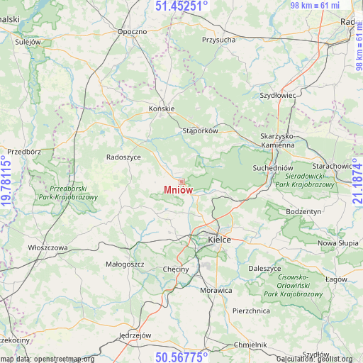
Mniów GPS coordinates[2]
51° 0' 44.064" North, 20° 29' 3.372" East
| Map corner | latitude | longitude |
|---|---|---|
| Upper-left | 51.45251°, | 19.78115° |
| Center: | 51.01224°, | 20.48427° |
| Lower-right: | 50.56775°, | 21.1874° |
| Map W x H: | 98.4×98.4 km | = 61.1×61.1mi |
| max Lat: | 54.83135° ⇑55.2% North |
| Mniów: | 51.01224° |
| min Lat: | ⇓44.8% South 49.21328° |
| min Long | Mniów | max Long |
| 14.20249° | 20.48427° | 24.03723° |
| W 64.9%⇐ | ⇒35.1% E |
Elevation
Elevation of Mniów is 275 m = 902 ft, and this is 83.6 m = 274 ft above average elevation for this country.
| Max E: |
974 m = 3196 ft | 18.1% |
| Mniów | 275 m 902 ft | |
| Avg. | 191.4 m = 628 ft | |
Min E: |
-3 m = -10 ft | 81.9% |
See also: Poland elevation on elevation.city.
Geographical zone
Mniów is located in North temperate zone (between Tropic of Cancer and the Arctic Circle). Distance of this North polar circle is 1729.1 km =1074.4 mi to North.| Distance of | km | miles | from Mniów |
|---|---|---|---|
| North Pole | 4335 | 2693.6 | to North |
| Arctic Circle | 1729.1 | 1074.4 | to North |
| Tropic Cancer | 3066.1 | 1905.2 | to South |
| Equator | 5672 | 3524.4 | to South |


Nearby cities:
15 places around Mniów: (largest is in red/bold)
• Gózd
19.9 km =12.4 mi,  99°
99°
• Kaniów
12.9 km =8 mi, 103°
• Kielce
18.7 km =11.6 mi,  147°
147°
• Kostomłoty Drugie
11.1 km =6.9 mi, 149°
• Kostomłoty Pierwsze
12.6 km =7.8 mi,  141°
141°
• Miedziana Góra
9.6 km =6 mi, 150°
• Oblęgórek
6.5 km =4 mi,  180°
180°
• Piekoszów
14.7 km =9.1 mi,  185°
185°
• Radoszyce
17.2 km =10.7 mi,  293°
293°
• Smyków
6.9 km =4.3 mi,  301°
301°
• Strawczyn
9 km =5.6 mi,  209°
209°
• Stąporków
15.2 km =9.4 mi,  23°
23°
• Zagnańsk
13 km =8.1 mi,  105°
105°
• Łopuszno
17.8 km =11.1 mi,  246°
246°
• Świerczów
15.3 km =9.5 mi,  41°
41°
Sources, notices
• [Note1] Compared only with cities in Poland existing in our database
• [Src1] Map data: © OpenStreetMap contributors (CC-BY-SA)
• [Src2] Other city data from geonames.org with taken over terms of usage.
• [Src3] Geographical zone / Annual Mean Temperature by Robert A. Rohde @ Wikipedia
