Smyków geodata
Smyków (Świętokrzyskie) is a seat of a third-order administrative division; located in Poland in Europe/Warsaw (GMT+2) time zone. With population of 290 people, there are 3624 cities with bigger population in this country. Compared to other cities in Poland, 54.1% of cities are located further ↑North; 63.7% of cities are located further ←West and 85.3% of cities have lower elevation than Smyków. Note1


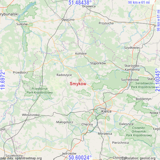
Smyków GPS coordinates[2]
51° 2' 39.912" North, 20° 24' 1.152" East
| Map corner | latitude | longitude |
|---|---|---|
| Upper-left | 51.48438°, | 19.6972° |
| Center: | 51.04442°, | 20.40032° |
| Lower-right: | 50.60024°, | 21.10345° |
| Map W x H: | 98.3×98.3 km | = 61.1×61.1mi |
| max Lat: | 54.83135° ⇑54.1% North |
| Smyków: | 51.04442° |
| min Lat: | ⇓45.9% South 49.21328° |
| min Long | Smyków | max Long |
| 14.20249° | 20.40032° | 24.03723° |
| W 63.7%⇐ | ⇒36.3% E |
Elevation
Elevation of Smyków is 291 m = 955 ft, and this is 99.6 m = 327 ft above average elevation for this country.
| Max E: |
974 m = 3196 ft | 14.7% |
| Smyków | 291 m 955 ft | |
| Avg. | 191.4 m = 628 ft | |
Min E: |
-3 m = -10 ft | 85.3% |
See also: Poland elevation on elevation.city.
Geographical zone
Smyków is located in North temperate zone (between Tropic of Cancer and the Arctic Circle). Distance of this North polar circle is 1725.6 km =1072.2 mi to North.| Distance of | km | miles | from Smyków |
|---|---|---|---|
| North Pole | 4331.5 | 2691.5 | to North |
| Arctic Circle | 1725.6 | 1072.2 | to North |
| Tropic Cancer | 3069.7 | 1907.4 | to South |
| Equator | 5675.6 | 3526.7 | to South |


Nearby cities:
15 places around Smyków: (largest is in red/bold)
• Kostomłoty Drugie
17.4 km =10.8 mi,  138°
138°
• Kostomłoty Pierwsze
19.2 km =11.9 mi,  134°
134°
• Końskie
16.4 km =10.2 mi,  1°
1°
• Miedziana Góra
15.9 km =9.9 mi, 138°
• Mniów
6.9 km =4.3 mi,  121°
121°
• Oblęgórek
11.6 km =7.2 mi,  149°
149°
• Piekoszów
18.8 km =11.7 mi,  166°
166°
• Radoszyce
10.4 km =6.5 mi,  288°
288°
• Rogów
17.9 km =11.1 mi,  7°
7°
• Ruda Maleniecka
16.7 km =10.4 mi,  312°
312°
• Strawczyn
11.5 km =7.1 mi, 172°
• Stąporków
15.8 km =9.8 mi,  49°
49°
• Słupia
18.5 km =11.5 mi,  259°
259°
• Łopuszno
14.9 km =9.3 mi,  224°
224°
• Świerczów
17.9 km =11.1 mi,  63°
63°
Sources, notices
• [Note1] Compared only with cities in Poland existing in our database
• [Src1] Map data: © OpenStreetMap contributors (CC-BY-SA)
• [Src2] Other city data from geonames.org with taken over terms of usage.
• [Src3] Geographical zone / Annual Mean Temperature by Robert A. Rohde @ Wikipedia
