Kielce geodata
Kielce (Świętokrzyskie) is a seat of a first-order administrative division; located in Poland in Europe/Warsaw (GMT+2) time zone. With population of 208,598 people, there are 17 cities with bigger population in this country. Compared to other cities in Poland, 58.5% of cities are located further ↑North; 66.6% of cities are located further ←West and 80.3% of cities have lower elevation than Kielce. Note1


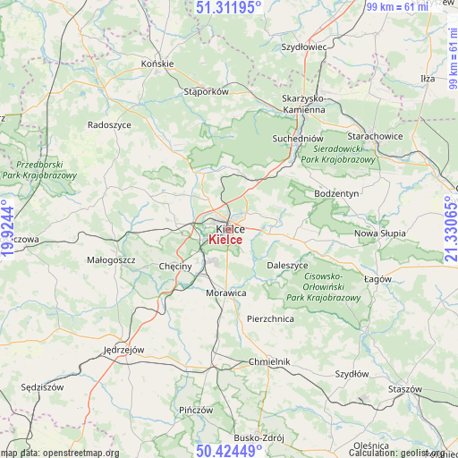
Kielce GPS coordinates[2]
50° 52' 13.188" North, 20° 37' 39.072" East
| Map corner | latitude | longitude |
|---|---|---|
| Upper-left | 51.31195°, | 19.9244° |
| Center: | 50.87033°, | 20.62752° |
| Lower-right: | 50.42449°, | 21.33065° |
| Map W x H: | 98.7×98.7 km | = 61.3×61.3mi |
| max Lat: | 54.83135° ⇑58.5% North |
| Kielce: | 50.87033° |
| min Lat: | ⇓41.5% South 49.21328° |
| min Long | Kielce | max Long |
| 14.20249° | 20.62752° | 24.03723° |
| W 66.6%⇐ | ⇒33.4% E |
Elevation
Elevation of Kielce is 267 m = 876 ft, and this is 75.6 m = 248 ft above average elevation for this country.
| Max E: |
974 m = 3196 ft | 19.7% |
| Kielce | 267 m 876 ft | |
| Avg. | 191.4 m = 628 ft | |
Min E: |
-3 m = -10 ft | 80.3% |
See also: Kielce elevation on elevation.city.
Geographical zone
Kielce is located in North temperate zone (between Tropic of Cancer and the Arctic Circle). Distance of this North polar circle is 1744.9 km =1084.2 mi to North.| Distance of | km | miles | from Kielce |
|---|---|---|---|
| North Pole | 4350.8 | 2703.5 | to North |
| Arctic Circle | 1744.9 | 1084.2 | to North |
| Tropic Cancer | 3050.3 | 1895.4 | to South |
| Equator | 5656.3 | 3514.7 | to South |


Nearby cities:
15 places around Kielce: (largest is in red/bold)
• Brzeziny
11.5 km =7.1 mi,  199°
199°
• Chęciny
14 km =8.7 mi,  236°
236°
• Daleszyce
14.8 km =9.2 mi,  120°
120°
• Domaszowice
3.9 km =2.4 mi,  82°
82°
• Górno
14.1 km =8.8 mi,  100°
100°
• Kaniów
13.1 km =8.1 mi,  11°
11°
• Kostomłoty Drugie
7.7 km =4.8 mi,  325°
325°
• Kostomłoty Pierwsze
6.3 km =3.9 mi,  338°
338°
• Masłów
7.5 km =4.7 mi,  63°
63°
• Miedziana Góra
9.1 km =5.7 mi,  324°
324°
• Morawica
13.8 km =8.6 mi,  182°
182°
• Oblęgórek
13.7 km =8.5 mi,  312°
312°
• Osiedle-Nowiny
8.4 km =5.2 mi,  226°
226°
• Piekoszów
11.5 km =7.1 mi,  275°
275°
• Zagnańsk
12.5 km =7.8 mi, 11°
Sources, notices
• [Note1] Compared only with cities in Poland existing in our database
• [Src1] Map data: © OpenStreetMap contributors (CC-BY-SA)
• [Src2] Other city data from geonames.org with taken over terms of usage.
• [Src3] Geographical zone / Annual Mean Temperature by Robert A. Rohde @ Wikipedia
