Końskowola geodata
Końskowola (Lublin) is a seat of a third-order administrative division; located in Poland in Europe/Warsaw (GMT+2) time zone. With population of 2,208 people, there are 1356 cities with bigger population in this country. Compared to other cities in Poland, 55% of cities are located further ↓South; 85.4% of cities are located further ←West and 63% of cities have higher elevation than Końskowola. Note1


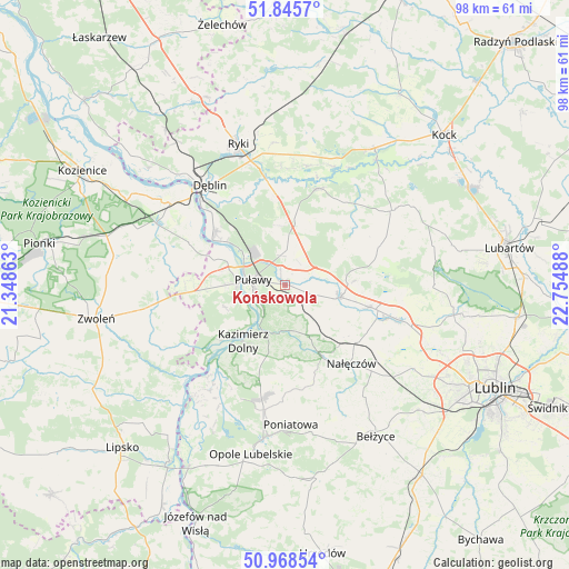
Końskowola GPS coordinates[2]
51° 24' 33.192" North, 22° 3' 6.3" East
| Map corner | latitude | longitude |
|---|---|---|
| Upper-left | 51.8457°, | 21.34863° |
| Center: | 51.40922°, | 22.05175° |
| Lower-right: | 50.96854°, | 22.75488° |
| Map W x H: | 97.5×97.5 km | = 60.6×60.6mi |
| max Lat: | 54.83135° ⇑45% North |
| Końskowola: | 51.40922° |
| min Lat: | ⇓55% South 49.21328° |
| min Long | Końskowola | max Long |
| 14.20249° | 22.05175° | 24.03723° |
| W 85.4%⇐ | ⇒14.6% E |
Elevation
Elevation of Końskowola is 139 m = 456 ft, and this is 52.4 m = 172 ft below average elevation for this country.
| Max E: |
974 m = 3196 ft | 63% |
| Avg. | 191.4 m = 628 ft | |
| Końskowola | 139 m = 456 ft | |
Min E: |
-3 m = -10 ft | 37% |
See also: Poland elevation on elevation.city.
Geographical zone
Końskowola is located in North temperate zone (between Tropic of Cancer and the Arctic Circle). Distance of this North polar circle is 1685 km =1047 mi to North.| Distance of | km | miles | from Końskowola |
|---|---|---|---|
| North Pole | 4290.9 | 2666.2 | to North |
| Arctic Circle | 1685 | 1047 | to North |
| Tropic Cancer | 3110.3 | 1932.7 | to South |
| Equator | 5716.2 | 3551.9 | to South |


Nearby cities:
15 places around Końskowola: (largest is in red/bold)
• Abramów
19 km =11.8 mi,  73°
73°
• Baranów
17.5 km =10.9 mi,  19°
19°
• Bałtów
9.2 km =5.7 mi,  347°
347°
• Bobrowniki
17.6 km =10.9 mi,  332°
332°
• Brzozowa Gać
8.9 km =5.5 mi,  98°
98°
• Gniewoszów
18.1 km =11.2 mi,  293°
293°
• Janowiec
14.8 km =9.2 mi,  229°
229°
• Kazimierz Dolny
12.1 km =7.5 mi,  213°
213°
• Kurów
9.6 km =6 mi, 103°
• Markuszów
14.8 km =9.2 mi,  105°
105°
• Nałęczów
17.8 km =11.1 mi,  140°
140°
• Przybysławice
16.5 km =10.3 mi, 105°
• Puławy
5.8 km =3.6 mi,  278°
278°
• Wąwolnica
14.3 km =8.9 mi,  152°
152°
• Żyrzyn
10.4 km =6.5 mi, 15°
Sources, notices
• [Note1] Compared only with cities in Poland existing in our database
• [Src1] Map data: © OpenStreetMap contributors (CC-BY-SA)
• [Src2] Other city data from geonames.org with taken over terms of usage.
• [Src3] Geographical zone / Annual Mean Temperature by Robert A. Rohde @ Wikipedia
