Latowicz geodata
Latowicz (Mazovia) is a seat of a third-order administrative division; located in Poland in Europe/Warsaw (GMT+2) time zone. With population of 1,401 people, there are 1957 cities with bigger population in this country. Compared to other cities in Poland, 66.1% of cities are located further ↓South; 82.3% of cities are located further ←West and 60.3% of cities have higher elevation than Latowicz. Note1


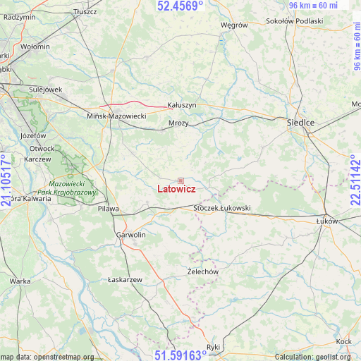
Latowicz GPS coordinates[2]
52° 1' 34.896" North, 21° 48' 29.844" East
| Map corner | latitude | longitude |
|---|---|---|
| Upper-left | 52.4569°, | 21.10517° |
| Center: | 52.02636°, | 21.80829° |
| Lower-right: | 51.59163°, | 22.51142° |
| Map W x H: | 96.2×96.2 km | = 59.8×59.8mi |
| max Lat: | 54.83135° ⇑33.9% North |
| Latowicz: | 52.02636° |
| min Lat: | ⇓66.1% South 49.21328° |
| min Long | Latowicz | max Long |
| 14.20249° | 21.80829° | 24.03723° |
| W 82.3%⇐ | ⇒17.7% E |
Elevation
Elevation of Latowicz is 146 m = 479 ft, and this is 45.4 m = 149 ft below average elevation for this country.
| Max E: |
974 m = 3196 ft | 60.3% |
| Avg. | 191.4 m = 628 ft | |
| Latowicz | 146 m = 479 ft | |
Min E: |
-3 m = -10 ft | 39.7% |
See also: Poland elevation on elevation.city.
Geographical zone
Latowicz is located in North temperate zone (between Tropic of Cancer and the Arctic Circle). Distance of this North polar circle is 1616.4 km =1004.4 mi to North.| Distance of | km | miles | from Latowicz |
|---|---|---|---|
| North Pole | 4222.3 | 2623.6 | to North |
| Arctic Circle | 1616.4 | 1004.4 | to North |
| Tropic Cancer | 3178.9 | 1975.3 | to South |
| Equator | 5784.8 | 3594.5 | to South |


Nearby cities:
15 places around Latowicz: (largest is in red/bold)
• Borowie
9.1 km =5.7 mi,  198°
198°
• Cegłów
14.3 km =8.9 mi,  340°
340°
• Garwolin
19.5 km =12.1 mi,  222°
222°
• Kałuszyn
20.1 km =12.5 mi,  0°
0°
• Miastków Kościelny
15.9 km =9.9 mi,  175°
175°
• Miętne
19.8 km =12.3 mi,  233°
233°
• Mrozy
15.5 km =9.6 mi,  358°
358°
• Parysów
10.4 km =6.5 mi,  237°
237°
• Pilawa
20.4 km =12.7 mi,  248°
248°
• Pogorzel
18 km =11.2 mi,  302°
302°
• Siennica
14.8 km =9.2 mi, 299°
• Stoczek Łukowski
13.3 km =8.3 mi,  122°
122°
• Trąbki
16.8 km =10.4 mi, 238°
• Wielgolas
5.2 km =3.2 mi,  276°
276°
• Wodynie
10.2 km =6.3 mi,  81°
81°
Sources, notices
• [Note1] Compared only with cities in Poland existing in our database
• [Src1] Map data: © OpenStreetMap contributors (CC-BY-SA)
• [Src2] Other city data from geonames.org with taken over terms of usage.
• [Src3] Geographical zone / Annual Mean Temperature by Robert A. Rohde @ Wikipedia
