Żelechów geodata
Żelechów (Mazovia) is a seat of a third-order administrative division; located in Poland in Europe/Warsaw (GMT+2) time zone. With population of 4,087 people, there are 801 cities with bigger population in this country. Compared to other cities in Poland, 62.3% of cities are located further ↓South; 83.4% of cities are located further ←West and 50.2% of cities have higher elevation than Żelechów. Note1


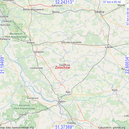
Żelechów GPS coordinates[2]
51° 48' 37.836" North, 21° 53' 49.956" East
| Map corner | latitude | longitude |
|---|---|---|
| Upper-left | 52.24313°, | 21.19409° |
| Center: | 51.81051°, | 21.89721° |
| Lower-right: | 51.37369°, | 22.60034° |
| Map W x H: | 96.7×96.7 km | = 60.1×60.1mi |
| max Lat: | 54.83135° ⇑37.7% North |
| Żelechów: | 51.81051° |
| min Lat: | ⇓62.3% South 49.21328° |
| min Long | Żelechów | max Long |
| 14.20249° | 21.89721° | 24.03723° |
| W 83.4%⇐ | ⇒16.6% E |
Elevation
Elevation of Żelechów is 171 m = 561 ft, and this is 20.4 m = 67 ft below average elevation for this country.
| Max E: |
974 m = 3196 ft | 50.2% |
| Avg. | 191.4 m = 628 ft | |
| Żelechów | 171 m = 561 ft | |
Min E: |
-3 m = -10 ft | 49.8% |
See also: Poland elevation on elevation.city.
Geographical zone
Żelechów is located in North temperate zone (between Tropic of Cancer and the Arctic Circle). Distance of this North polar circle is 1640.4 km =1019.3 mi to North.| Distance of | km | miles | from Żelechów |
|---|---|---|---|
| North Pole | 4246.3 | 2638.5 | to North |
| Arctic Circle | 1640.4 | 1019.3 | to North |
| Tropic Cancer | 3154.9 | 1960.4 | to South |
| Equator | 5760.8 | 3579.6 | to South |


Nearby cities:
15 places around Żelechów: (largest is in red/bold)
• Borowie
17.9 km =11.1 mi,  329°
329°
• Garwolin
21.7 km =13.5 mi,  296°
296°
• Górzno
13.5 km =8.4 mi,  287°
287°
• Kawęczyn
13 km =8.1 mi,  146°
146°
• Krzywda
20.9 km =13 mi,  94°
94°
• Kłoczew
11 km =6.8 mi, 154°
• Miastków Kościelny
9.6 km =6 mi, 328°
• Podebłocie
21.7 km =13.5 mi,  209°
209°
• Ryki
20.7 km =12.9 mi,  173°
173°
• Sobolew
18.1 km =11.2 mi,  242°
242°
• Stanin
22 km =13.7 mi,  72°
72°
• Stoczek Łukowski
17.5 km =10.9 mi,  16°
16°
• Sulbiny Górne
19.5 km =12.1 mi, 290°
• Trojanów
14.4 km =8.9 mi,  204°
204°
• Łaskarzew
21.2 km =13.2 mi,  263°
263°
Sources, notices
• [Note1] Compared only with cities in Poland existing in our database
• [Src1] Map data: © OpenStreetMap contributors (CC-BY-SA)
• [Src2] Other city data from geonames.org with taken over terms of usage.
• [Src3] Geographical zone / Annual Mean Temperature by Robert A. Rohde @ Wikipedia
