Sterkowiec geodata
Sterkowiec (Lesser Poland) is a populated place; located in Poland in Europe/Warsaw (GMT+2) time zone. With population of 840 people, there are 2782 cities with bigger population in this country. Compared to other cities in Poland, 82.7% of cities are located further ↑North; 67.2% of cities are located further ←West and 63.8% of cities have lower elevation than Sterkowiec. Note1


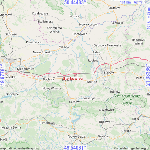
Sterkowiec GPS coordinates[2]
49° 59' 41.784" North, 20° 40' 50.628" East
| Map corner | latitude | longitude |
|---|---|---|
| Upper-left | 50.44483°, | 19.97761° |
| Center: | 49.99494°, | 20.68073° |
| Lower-right: | 49.54081°, | 21.38386° |
| Map W x H: | 100.5×100.5 km | = 62.4×62.4mi |
| max Lat: | 54.83135° ⇑82.7% North |
| Sterkowiec: | 49.99494° |
| min Lat: | ⇓17.3% South 49.21328° |
| min Long | Sterkowiec | max Long |
| 14.20249° | 20.68073° | 24.03723° |
| W 67.2%⇐ | ⇒32.8% E |
Elevation
Elevation of Sterkowiec is 211 m = 692 ft, and this is 19.6 m = 64 ft above average elevation for this country.
| Max E: |
974 m = 3196 ft | 36.2% |
| Sterkowiec | 211 m 692 ft | |
| Avg. | 191.4 m = 628 ft | |
Min E: |
-3 m = -10 ft | 63.8% |
See also: Poland elevation on elevation.city.
Geographical zone
Sterkowiec is located in North temperate zone (between Tropic of Cancer and the Arctic Circle). Distance of this North polar circle is 1842.3 km =1144.8 mi to North.| Distance of | km | miles | from Sterkowiec |
|---|---|---|---|
| North Pole | 4448.1 | 2763.9 | to North |
| Arctic Circle | 1842.3 | 1144.8 | to North |
| Tropic Cancer | 2953 | 1834.9 | to South |
| Equator | 5558.9 | 3454.1 | to South |


Nearby cities:
15 places around Sterkowiec: (largest is in red/bold)
• Borzęcin
8.1 km =5 mi,  15°
15°
• Brzesko
6.1 km =3.8 mi,  241°
241°
• Dębno
4.2 km =2.6 mi,  138°
138°
• Jadowniki
4.8 km =3 mi,  212°
212°
• Jasień
8.3 km =5.2 mi,  250°
250°
• Jodłówka
9.5 km =5.9 mi,  268°
268°
• Maszkienice
0.8 km =0.5 mi,  146°
146°
• Okocim
7.6 km =4.7 mi,  227°
227°
• Porąbka Uszewska
5.9 km =3.7 mi,  173°
173°
• Przyborów
4.1 km =2.5 mi,  341°
341°
• Rudy-Rysie
8 km =5 mi, 337°
• Szczepanów
2.2 km =1.4 mi,  301°
301°
• Wokowice
1.9 km =1.2 mi,  48°
48°
• Wola Dębińska
1.5 km =0.9 mi,  160°
160°
• Łoniowa
8.8 km =5.5 mi, 173°
Sources, notices
• [Note1] Compared only with cities in Poland existing in our database
• [Src1] Map data: © OpenStreetMap contributors (CC-BY-SA)
• [Src2] Other city data from geonames.org with taken over terms of usage.
• [Src3] Geographical zone / Annual Mean Temperature by Robert A. Rohde @ Wikipedia
