Maszkienice geodata
Maszkienice (Lesser Poland) is a populated place; located in Poland in Europe/Warsaw (GMT+2) time zone. With population of 1,401 people, there are 1957 cities with bigger population in this country. Compared to other cities in Poland, 83.1% of cities are located further ↑North; 67.3% of cities are located further ←West and 61.9% of cities have lower elevation than Maszkienice. Note1


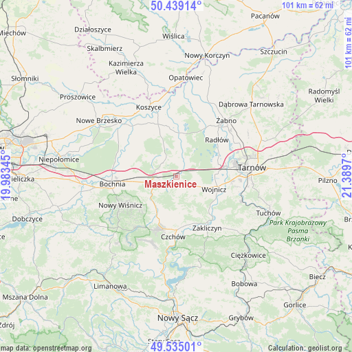
Maszkienice GPS coordinates[2]
49° 59' 21.12" North, 20° 41' 11.652" East
| Map corner | latitude | longitude |
|---|---|---|
| Upper-left | 50.43914°, | 19.98345° |
| Center: | 49.9892°, | 20.68657° |
| Lower-right: | 49.53501°, | 21.3897° |
| Map W x H: | 100.5×100.5 km | = 62.4×62.4mi |
| max Lat: | 54.83135° ⇑83.1% North |
| Maszkienice: | 49.9892° |
| min Lat: | ⇓16.9% South 49.21328° |
| min Long | Maszkienice | max Long |
| 14.20249° | 20.68657° | 24.03723° |
| W 67.3%⇐ | ⇒32.7% E |
Elevation
Elevation of Maszkienice is 205 m = 673 ft, and this is 13.6 m = 45 ft above average elevation for this country.
| Max E: |
974 m = 3196 ft | 38.1% |
| Maszkienice | 205 m 673 ft | |
| Avg. | 191.4 m = 628 ft | |
Min E: |
-3 m = -10 ft | 61.9% |
See also: Poland elevation on elevation.city.
Geographical zone
Maszkienice is located in North temperate zone (between Tropic of Cancer and the Arctic Circle). Distance of this North polar circle is 1842.9 km =1145.1 mi to North.| Distance of | km | miles | from Maszkienice |
|---|---|---|---|
| North Pole | 4448.8 | 2764.4 | to North |
| Arctic Circle | 1842.9 | 1145.1 | to North |
| Tropic Cancer | 2952.4 | 1834.5 | to South |
| Equator | 5558.3 | 3453.8 | to South |


Nearby cities:
15 places around Maszkienice: (largest is in red/bold)
• Borzęcin
8.7 km =5.4 mi,  11°
11°
• Brzesko
6.2 km =3.9 mi,  248°
248°
• Dębno
3.4 km =2.1 mi,  136°
136°
• Jadowniki
4.5 km =2.8 mi,  221°
221°
• Jasień
8.5 km =5.3 mi,  255°
255°
• Jodłówka
9.9 km =6.2 mi,  272°
272°
• Okocim
7.6 km =4.7 mi,  233°
233°
• Porąbka Uszewska
5.2 km =3.2 mi,  176°
176°
• Przyborów
4.9 km =3 mi,  339°
339°
• Rudy-Rysie
8.7 km =5.4 mi, 336°
• Sterkowiec
0.8 km =0.5 mi,  326°
326°
• Szczepanów
2.9 km =1.8 mi,  307°
307°
• Wokowice
2.1 km =1.3 mi,  27°
27°
• Wola Dębińska
0.8 km =0.5 mi,  173°
173°
• Łoniowa
8.1 km =5 mi, 176°
Sources, notices
• [Note1] Compared only with cities in Poland existing in our database
• [Src1] Map data: © OpenStreetMap contributors (CC-BY-SA)
• [Src2] Other city data from geonames.org with taken over terms of usage.
• [Src3] Geographical zone / Annual Mean Temperature by Robert A. Rohde @ Wikipedia
