Mały Płock geodata
Mały Płock (Podlasie) is a populated place; located in Poland in Europe/Warsaw (GMT+2) time zone. With population of 1,051 people, there are 2404 cities with bigger population in this country. Compared to other cities in Poland, 87.5% of cities are located further ↓South; 85.2% of cities are located further ←West and 62.7% of cities have higher elevation than Mały Płock. Note1


Mały Płock GPS coordinates[2]
53° 18' 13.86" North, 22° 1' 42.096" East
| Map corner | latitude | longitude |
|---|---|---|
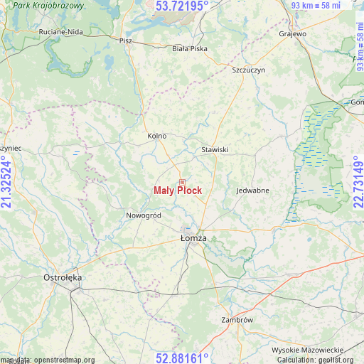
| Upper-left | 53.72195°, | 21.32524° |
| Center: | 53.30385°, | 22.02836° |
| Lower-right: | 52.88161°, | 22.73149° |
| Map W x H: | 93.4×93.4 km | = 58×58mi |
| max Lat: | 54.83135° ⇑12.5% North |
| Mały Płock: | 53.30385° |
| min Lat: | ⇓87.5% South 49.21328° |
| min Long | Mały Płock | max Long |
| 14.20249° | 22.02836° | 24.03723° |
| W 85.2%⇐ | ⇒14.8% E |
Elevation
Elevation of Mały Płock is 140 m = 459 ft, and this is 51.4 m = 169 ft below average elevation for this country.
| Max E: |
974 m = 3196 ft | 62.7% |
| Avg. | 191.4 m = 628 ft | |
| Mały Płock | 140 m = 459 ft | |
Min E: |
-3 m = -10 ft | 37.3% |
See also: Poland elevation on elevation.city.
Geographical zone
Mały Płock is located in North temperate zone (between Tropic of Cancer and the Arctic Circle). Distance of this North polar circle is 1474.3 km =916.1 mi to North.| Distance of | km | miles | from Mały Płock |
|---|---|---|---|
| North Pole | 4080.2 | 2535.3 | to North |
| Arctic Circle | 1474.3 | 916.1 | to North |
| Tropic Cancer | 3320.9 | 2063.5 | to South |
| Equator | 5926.8 | 3682.7 | to South |


Nearby cities:
15 places around Mały Płock: (largest is in red/bold)
• Czarnocin
10.5 km =6.5 mi,  161°
161°
• Gać
28.8 km =17.9 mi,  149°
149°
• Grabowo
19.9 km =12.4 mi,  24°
24°
• Janowo
9.1 km =5.7 mi,  306°
306°
• Jedwabne
18.4 km =11.4 mi,  96°
96°
• Kolno
13.7 km =8.5 mi,  331°
331°
• Miastkowo
22.2 km =13.8 mi,  219°
219°
• Nowogród
12.9 km =8 mi,  228°
228°
• Piątnica
12.7 km =7.9 mi, 159°
• Radziłów
27.9 km =17.3 mi,  65°
65°
• Stawiski
11.9 km =7.4 mi,  44°
44°
• Wizna
26.5 km =16.5 mi,  117°
117°
• Zbójna
17.4 km =10.8 mi,  247°
247°
• Łomża
14.1 km =8.8 mi,  171°
171°
• Śniadowo
29.6 km =18.4 mi,  184°
184°
Sources, notices
• [Note1] Compared only with cities in Poland existing in our database
• [Src1] Map data: © OpenStreetMap contributors (CC-BY-SA)
• [Src2] Other city data from geonames.org with taken over terms of usage.
• [Src3] Geographical zone / Annual Mean Temperature by Robert A. Rohde @ Wikipedia
