Janowo geodata
Janowo (Podlasie) is a populated place; located in Poland in Europe/Warsaw (GMT+2) time zone. With population of 505 people, there are 3528 cities with bigger population in this country. Compared to other cities in Poland, 88% of cities are located further ↓South; 83.7% of cities are located further ←West and 73.5% of cities have higher elevation than Janowo. Note1


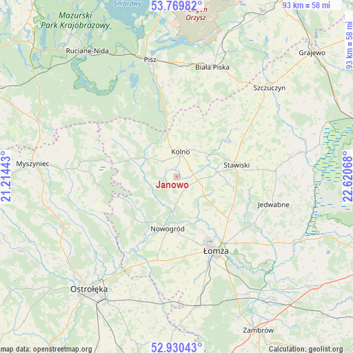
Janowo GPS coordinates[2]
53° 21' 7.884" North, 21° 55' 3.18" East
| Map corner | latitude | longitude |
|---|---|---|
| Upper-left | 53.76982°, | 21.21443° |
| Center: | 53.35219°, | 21.91755° |
| Lower-right: | 52.93043°, | 22.62068° |
| Map W x H: | 93.3×93.3 km | = 58×58mi |
| max Lat: | 54.83135° ⇑12% North |
| Janowo: | 53.35219° |
| min Lat: | ⇓88% South 49.21328° |
| min Long | Janowo | max Long |
| 14.20249° | 21.91755° | 24.03723° |
| W 83.7%⇐ | ⇒16.3% E |
Elevation
Elevation of Janowo is 114 m = 374 ft, and this is 77.4 m = 254 ft below average elevation for this country.
| Max E: |
974 m = 3196 ft | 73.5% |
| Avg. | 191.4 m = 628 ft | |
| Janowo | 114 m = 374 ft | |
Min E: |
-3 m = -10 ft | 26.5% |
See also: Poland elevation on elevation.city.
Geographical zone
Janowo is located in North temperate zone (between Tropic of Cancer and the Arctic Circle). Distance of this North polar circle is 1469 km =912.8 mi to North.| Distance of | km | miles | from Janowo |
|---|---|---|---|
| North Pole | 4074.9 | 2532 | to North |
| Arctic Circle | 1469 | 912.8 | to North |
| Tropic Cancer | 3326.3 | 2066.9 | to South |
| Equator | 5932.2 | 3686.1 | to South |


Nearby cities:
15 places around Janowo: (largest is in red/bold)
• Biała Piska
30.4 km =18.9 mi,  18°
18°
• Czarnocin
18.7 km =11.6 mi,  145°
145°
• Grabowo
20.1 km =12.5 mi,  51°
51°
• Jedwabne
26.7 km =16.6 mi,  106°
106°
• Kolno
6.6 km =4.1 mi,  6°
6°
• Lelis
30.5 km =19 mi,  231°
231°
• Mały Płock
9.1 km =5.7 mi,  126°
126°
• Miastkowo
23.4 km =14.5 mi,  196°
196°
• Nowogród
14.1 km =8.8 mi,  189°
189°
• Pisz
31.4 km =19.5 mi,  347°
347°
• Piątnica
21 km =13 mi, 145°
• Stawiski
16 km =9.9 mi,  78°
78°
• Zbójna
14.9 km =9.3 mi,  215°
215°
• Łomża
21.5 km =13.4 mi, 154°
• Łyse
23.4 km =14.5 mi,  273°
273°
Sources, notices
• [Note1] Compared only with cities in Poland existing in our database
• [Src1] Map data: © OpenStreetMap contributors (CC-BY-SA)
• [Src2] Other city data from geonames.org with taken over terms of usage.
• [Src3] Geographical zone / Annual Mean Temperature by Robert A. Rohde @ Wikipedia
