Kuźnica geodata
Kuźnica (Podlasie) is a populated place; located in Poland in Europe/Warsaw (GMT+2) time zone. With population of 1,740 people, there are 1652 cities with bigger population in this country. Compared to other cities in Poland, 89.7% of cities are located further ↓South; 99.3% of cities are located further ←West and 57.1% of cities have higher elevation than Kuźnica. Note1


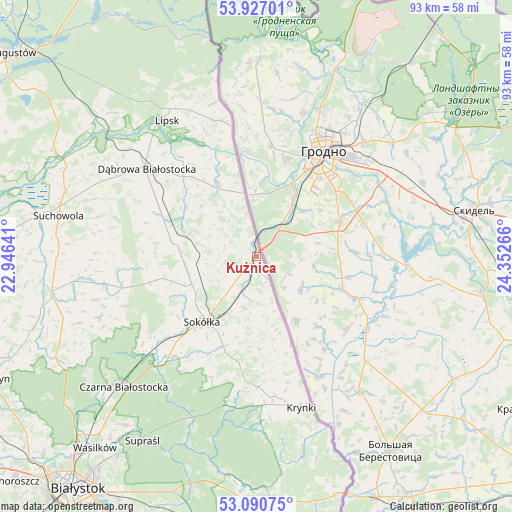
Kuźnica GPS coordinates[2]
53° 30' 39.384" North, 23° 38' 58.308" East
| Map corner | latitude | longitude |
|---|---|---|
| Upper-left | 53.92701°, | 22.94641° |
| Center: | 53.51094°, | 23.64953° |
| Lower-right: | 53.09075°, | 24.35266° |
| Map W x H: | 93×93 km | = 57.8×57.8mi |
| max Lat: | 54.83135° ⇑10.3% North |
| Kuźnica: | 53.51094° |
| min Lat: | ⇓89.7% South 49.21328° |
| min Long | Kuźnica | max Long |
| 14.20249° | 23.64953° | 24.03723° |
| W 99.3%⇐ | ⇒0.7% E |
Elevation
Elevation of Kuźnica is 153 m = 502 ft, and this is 38.4 m = 126 ft below average elevation for this country.
| Max E: |
974 m = 3196 ft | 57.1% |
| Avg. | 191.4 m = 628 ft | |
| Kuźnica | 153 m = 502 ft | |
Min E: |
-3 m = -10 ft | 42.9% |
See also: Poland elevation on elevation.city.
Geographical zone
Kuźnica is located in North temperate zone (between Tropic of Cancer and the Arctic Circle). Distance of this North polar circle is 1451.3 km =901.8 mi to North.| Distance of | km | miles | from Kuźnica |
|---|---|---|---|
| North Pole | 4057.2 | 2521 | to North |
| Arctic Circle | 1451.3 | 901.8 | to North |
| Tropic Cancer | 3343.9 | 2077.8 | to South |
| Equator | 5949.9 | 3697.1 | to South |


Nearby cities:
15 places around Kuźnica: (largest is in red/bold)
• Czarna Białostocka
33.5 km =20.8 mi,  226°
226°
• Dąbrowa Białostocka
25.5 km =15.8 mi,  308°
308°
• Janów
28.1 km =17.5 mi,  260°
260°
• Jasionówka
42.5 km =26.4 mi,  252°
252°
• Korycin
37.7 km =23.4 mi, 258°
• Krynki
28.6 km =17.8 mi,  163°
163°
• Lipsk
29.6 km =18.4 mi,  326°
326°
• Nowy Dwór
15.1 km =9.4 mi, 332°
• Sidra
14 km =8.7 mi,  289°
289°
• Sokółka
15.1 km =9.4 mi,  220°
220°
• Suchowola
36.7 km =22.8 mi,  281°
281°
• Supraśl
39.7 km =24.7 mi,  211°
211°
• Sztabin
41.1 km =25.5 mi,  297°
297°
• Szudziałowo
23.6 km =14.7 mi,  179°
179°
• Wasilków
45.4 km =28.2 mi, 220°
Sources, notices
• [Note1] Compared only with cities in Poland existing in our database
• [Src1] Map data: © OpenStreetMap contributors (CC-BY-SA)
• [Src2] Other city data from geonames.org with taken over terms of usage.
• [Src3] Geographical zone / Annual Mean Temperature by Robert A. Rohde @ Wikipedia
