Sokółka geodata
Sokółka (Podlasie) is a seat of a third-order administrative division; located in Poland in Europe/Warsaw (GMT+2) time zone. With population of 19,079 people, there are 251 cities with bigger population in this country. Compared to other cities in Poland, 88.6% of cities are located further ↓South; 98.8% of cities are located further ←West and 50.8% of cities have lower elevation than Sokółka. Note1


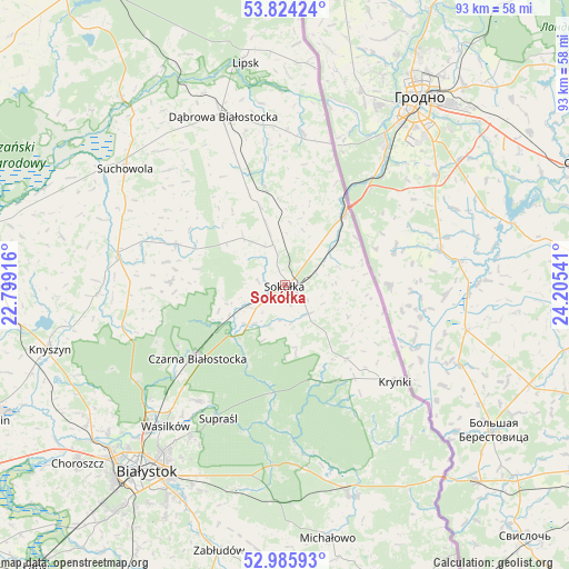
Sokółka GPS coordinates[2]
53° 24' 25.74" North, 23° 30' 8.208" East
| Map corner | latitude | longitude |
|---|---|---|
| Upper-left | 53.82424°, | 22.79916° |
| Center: | 53.40715°, | 23.50228° |
| Lower-right: | 52.98593°, | 24.20541° |
| Map W x H: | 93.2×93.2 km | = 57.9×57.9mi |
| max Lat: | 54.83135° ⇑11.4% North |
| Sokółka: | 53.40715° |
| min Lat: | ⇓88.6% South 49.21328° |
| min Long | Sokółka | max Long |
| 14.20249° | 23.50228° | 24.03723° |
| W 98.8%⇐ | ⇒1.2% E |
Elevation
Elevation of Sokółka is 174 m = 571 ft, and this is 17.4 m = 57 ft below average elevation for this country.
| Max E: |
974 m = 3196 ft | 49.2% |
| Avg. | 191.4 m = 628 ft | |
| Sokółka | 174 m = 571 ft | |
Min E: |
-3 m = -10 ft | 50.8% |
See also: Poland elevation on elevation.city.
Geographical zone
Sokółka is located in North temperate zone (between Tropic of Cancer and the Arctic Circle). Distance of this North polar circle is 1462.9 km =909 mi to North.| Distance of | km | miles | from Sokółka |
|---|---|---|---|
| North Pole | 4068.7 | 2528.2 | to North |
| Arctic Circle | 1462.9 | 909 | to North |
| Tropic Cancer | 3332.4 | 2070.7 | to South |
| Equator | 5938.3 | 3689.9 | to South |


Nearby cities:
15 places around Sokółka: (largest is in red/bold)
• Czarna Białostocka
18.5 km =11.5 mi,  232°
232°
• Dąbrowa Białostocka
29.2 km =18.1 mi,  339°
339°
• Grudki
36.4 km =22.6 mi,  162°
162°
• Janów
19.2 km =11.9 mi,  290°
290°
• Jasionówka
30.8 km =19.1 mi,  267°
267°
• Korycin
27.6 km =17.1 mi,  278°
278°
• Krynki
24 km =14.9 mi,  131°
131°
• Kuźnica
15.1 km =9.4 mi,  40°
40°
• Lipsk
36.8 km =22.9 mi,  349°
349°
• Nowy Dwór
25.1 km =15.6 mi,  6°
6°
• Sidra
16.5 km =10.3 mi, 347°
• Suchowola
32.3 km =20.1 mi,  305°
305°
• Supraśl
24.9 km =15.5 mi,  205°
205°
• Szudziałowo
15.7 km =9.8 mi,  140°
140°
• Wasilków
30.3 km =18.8 mi,  220°
220°
Sources, notices
• [Note1] Compared only with cities in Poland existing in our database
• [Src1] Map data: © OpenStreetMap contributors (CC-BY-SA)
• [Src2] Other city data from geonames.org with taken over terms of usage.
• [Src3] Geographical zone / Annual Mean Temperature by Robert A. Rohde @ Wikipedia
