Suchowola geodata
Suchowola (Podlasie) is a seat of a third-order administrative division; located in Poland in Europe/Warsaw (GMT+2) time zone. With population of 2,211 people, there are 1353 cities with bigger population in this country. Compared to other cities in Poland, 90.5% of cities are located further ↓South; 96.8% of cities are located further ←West and 62.1% of cities have higher elevation than Suchowola. Note1


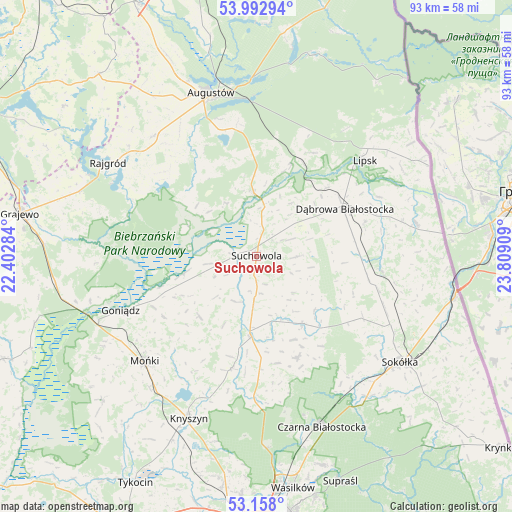
Suchowola GPS coordinates[2]
53° 34' 39.108" North, 23° 6' 21.456" East
| Map corner | latitude | longitude |
|---|---|---|
| Upper-left | 53.99294°, | 22.40284° |
| Center: | 53.57753°, | 23.10596° |
| Lower-right: | 53.158°, | 23.80909° |
| Map W x H: | 92.8×92.8 km | = 57.7×57.7mi |
| max Lat: | 54.83135° ⇑9.5% North |
| Suchowola: | 53.57753° |
| min Lat: | ⇓90.5% South 49.21328° |
| min Long | Suchowola | max Long |
| 14.20249° | 23.10596° | 24.03723° |
| W 96.8%⇐ | ⇒3.2% E |
Elevation
Elevation of Suchowola is 142 m = 466 ft, and this is 49.4 m = 162 ft below average elevation for this country.
| Max E: |
974 m = 3196 ft | 62.1% |
| Avg. | 191.4 m = 628 ft | |
| Suchowola | 142 m = 466 ft | |
Min E: |
-3 m = -10 ft | 37.9% |
See also: Poland elevation on elevation.city.
Geographical zone
Suchowola is located in North temperate zone (between Tropic of Cancer and the Arctic Circle). Distance of this North polar circle is 1443.9 km =897.2 mi to North.| Distance of | km | miles | from Suchowola |
|---|---|---|---|
| North Pole | 4049.8 | 2516.4 | to North |
| Arctic Circle | 1443.9 | 897.2 | to North |
| Tropic Cancer | 3351.3 | 2082.4 | to South |
| Equator | 5957.3 | 3701.7 | to South |


Nearby cities:
15 places around Suchowola: (largest is in red/bold)
• Augustów
30.7 km =19.1 mi,  344°
344°
• Bargłów Kościelny
28.7 km =17.8 mi,  319°
319°
• Dąbrowa Białostocka
18.1 km =11.2 mi,  62°
62°
• Goniadz
26.3 km =16.3 mi,  248°
248°
• Janów
14.7 km =9.1 mi,  146°
146°
• Jasionówka
20.8 km =12.9 mi,  192°
192°
• Jaświły
15 km =9.3 mi,  223°
223°
• Knyszyn
31.8 km =19.8 mi,  202°
202°
• Korycin
14.8 km =9.2 mi,  183°
183°
• Lipsk
26.1 km =16.2 mi,  48°
48°
• Mońki
28 km =17.4 mi,  226°
226°
• Nowy Dwór
29.5 km =18.3 mi,  78°
78°
• Rajgród
31.4 km =19.5 mi,  302°
302°
• Sidra
22.9 km =14.2 mi,  97°
97°
• Sztabin
11.6 km =7.2 mi,  357°
357°
Sources, notices
• [Note1] Compared only with cities in Poland existing in our database
• [Src1] Map data: © OpenStreetMap contributors (CC-BY-SA)
• [Src2] Other city data from geonames.org with taken over terms of usage.
• [Src3] Geographical zone / Annual Mean Temperature by Robert A. Rohde @ Wikipedia
