Nowy Dwór geodata
Nowy Dwór (Podlasie) is a populated place; located in Poland in Europe/Warsaw (GMT+2) time zone. With population of 830 people, there are 2797 cities with bigger population in this country. Compared to other cities in Poland, 90.8% of cities are located further ↓South; 98.9% of cities are located further ←West and 56.4% of cities have higher elevation than Nowy Dwór. Note1


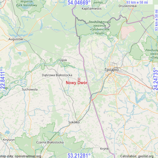
Nowy Dwór GPS coordinates[2]
53° 37' 54.516" North, 23° 32' 39.192" East
| Map corner | latitude | longitude |
|---|---|---|
| Upper-left | 54.04669°, | 22.8411° |
| Center: | 53.63181°, | 23.54422° |
| Lower-right: | 53.21281°, | 24.24735° |
| Map W x H: | 92.7×92.7 km | = 57.6×57.6mi |
| max Lat: | 54.83135° ⇑9.2% North |
| Nowy Dwór: | 53.63181° |
| min Lat: | ⇓90.8% South 49.21328° |
| min Long | Nowy Dwór | max Long |
| 14.20249° | 23.54422° | 24.03723° |
| W 98.9%⇐ | ⇒1.1% E |
Elevation
Elevation of Nowy Dwór is 155 m = 509 ft, and this is 36.4 m = 119 ft below average elevation for this country.
| Max E: |
974 m = 3196 ft | 56.4% |
| Avg. | 191.4 m = 628 ft | |
| Nowy Dwór | 155 m = 509 ft | |
Min E: |
-3 m = -10 ft | 43.6% |
See also: Poland elevation on elevation.city.
Geographical zone
Nowy Dwór is located in North temperate zone (between Tropic of Cancer and the Arctic Circle). Distance of this North polar circle is 1437.9 km =893.5 mi to North.| Distance of | km | miles | from Nowy Dwór |
|---|---|---|---|
| North Pole | 4043.8 | 2512.7 | to North |
| Arctic Circle | 1437.9 | 893.5 | to North |
| Tropic Cancer | 3357.4 | 2086.2 | to South |
| Equator | 5963.3 | 3705.4 | to South |


Nearby cities:
15 places around Nowy Dwór: (largest is in red/bold)
• Augustów
43.9 km =27.3 mi,  302°
302°
• Czarna Białostocka
40.3 km =25 mi,  205°
205°
• Dąbrowa Białostocka
13.2 km =8.2 mi,  280°
280°
• Janów
27.6 km =17.1 mi,  228°
228°
• Jasionówka
42.6 km =26.5 mi, 231°
• Jaświły
42.8 km =26.6 mi,  246°
246°
• Korycin
36.5 km =22.7 mi,  235°
235°
• Krynki
43.6 km =27.1 mi,  159°
159°
• Kuźnica
15.1 km =9.4 mi,  152°
152°
• Lipsk
14.6 km =9.1 mi,  320°
320°
• Sidra
10.8 km =6.7 mi,  215°
215°
• Sokółka
25.1 km =15.6 mi,  186°
186°
• Suchowola
29.5 km =18.3 mi,  258°
258°
• Sztabin
29.9 km =18.6 mi, 280°
• Szudziałowo
37.8 km =23.5 mi,  168°
168°
Sources, notices
• [Note1] Compared only with cities in Poland existing in our database
• [Src1] Map data: © OpenStreetMap contributors (CC-BY-SA)
• [Src2] Other city data from geonames.org with taken over terms of usage.
• [Src3] Geographical zone / Annual Mean Temperature by Robert A. Rohde @ Wikipedia
