Lipinki geodata
Lipinki (Lesser Poland) is a populated place; located in Poland in Europe/Warsaw (GMT+2) time zone. With population of 2,157 people, there are 1385 cities with bigger population in this country. Compared to other cities in Poland, 95.3% of cities are located further ↑North; 76.9% of cities are located further ←West and 88.3% of cities have lower elevation than Lipinki. Note1


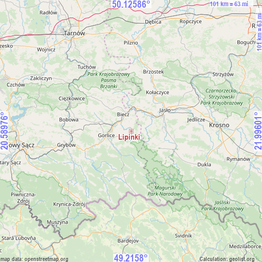
Lipinki GPS coordinates[2]
49° 40' 22.656" North, 21° 17' 34.368" East
| Map corner | latitude | longitude |
|---|---|---|
| Upper-left | 50.12586°, | 20.58976° |
| Center: | 49.67296°, | 21.29288° |
| Lower-right: | 49.2158°, | 21.99601° |
| Map W x H: | 101.2×101.2 km | = 62.9×62.9mi |
| max Lat: | 54.83135° ⇑95.3% North |
| Lipinki: | 49.67296° |
| min Lat: | ⇓4.7% South 49.21328° |
| min Long | Lipinki | max Long |
| 14.20249° | 21.29288° | 24.03723° |
| W 76.9%⇐ | ⇒23.1% E |
Elevation
Elevation of Lipinki is 311 m = 1020 ft, and this is 119.6 m = 392 ft above average elevation for this country.
| Max E: |
974 m = 3196 ft | 11.7% |
| Lipinki | 311 m 1020 ft | |
| Avg. | 191.4 m = 628 ft | |
Min E: |
-3 m = -10 ft | 88.3% |
See also: Poland elevation on elevation.city.
Geographical zone
Lipinki is located in North temperate zone (between Tropic of Cancer and the Arctic Circle). Distance of this North polar circle is 1878.1 km =1167 mi to North.| Distance of | km | miles | from Lipinki |
|---|---|---|---|
| North Pole | 4483.9 | 2786.2 | to North |
| Arctic Circle | 1878.1 | 1167 | to North |
| Tropic Cancer | 2917.2 | 1812.7 | to South |
| Equator | 5523.1 | 3431.9 | to South |


Nearby cities:
15 places around Lipinki: (largest is in red/bold)
• Biecz
7.3 km =4.5 mi,  342°
342°
• Binarowa
10.4 km =6.5 mi,  333°
333°
• Dębowiec
12.1 km =7.5 mi,  84°
84°
• Gorlice
9.7 km =6 mi,  258°
258°
• Jabłonica
13.7 km =8.5 mi,  10°
10°
• Kobylanka
5.1 km =3.2 mi, 264°
• Korczyna
5.3 km =3.3 mi, 325°
• Kwiatonowice
10.8 km =6.7 mi,  299°
299°
• Lipnica Dolna
13.9 km =8.6 mi,  28°
28°
• Pielgrzymka
12.4 km =7.7 mi,  120°
120°
• Racławice
11.3 km =7 mi,  318°
318°
• Skołyszyn
9.1 km =5.7 mi,  20°
20°
• Sękowa
8.9 km =5.5 mi,  230°
230°
• Trzcinica
11.9 km =7.4 mi,  49°
49°
• Zarzecze
13.6 km =8.5 mi,  88°
88°
Sources, notices
• [Note1] Compared only with cities in Poland existing in our database
• [Src1] Map data: © OpenStreetMap contributors (CC-BY-SA)
• [Src2] Other city data from geonames.org with taken over terms of usage.
• [Src3] Geographical zone / Annual Mean Temperature by Robert A. Rohde @ Wikipedia
