Zarzecze geodata
Zarzecze (Subcarpathian) is a populated place; located in Poland in Europe/Warsaw (GMT+2) time zone. With population of 999 people, there are 2501 cities with bigger population in this country. Compared to other cities in Poland, 95.1% of cities are located further ↑North; 78.9% of cities are located further ←West and 77% of cities have lower elevation than Zarzecze. Note1


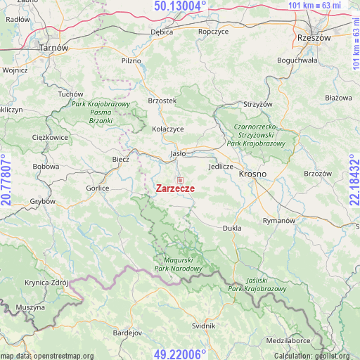
Zarzecze GPS coordinates[2]
49° 40' 37.848" North, 21° 28' 52.284" East
| Map corner | latitude | longitude |
|---|---|---|
| Upper-left | 50.13004°, | 20.77807° |
| Center: | 49.67718°, | 21.48119° |
| Lower-right: | 49.22006°, | 22.18432° |
| Map W x H: | 101.2×101.2 km | = 62.9×62.9mi |
| max Lat: | 54.83135° ⇑95.1% North |
| Zarzecze: | 49.67718° |
| min Lat: | ⇓4.9% South 49.21328° |
| min Long | Zarzecze | max Long |
| 14.20249° | 21.48119° | 24.03723° |
| W 78.9%⇐ | ⇒21.1% E |
Elevation
Elevation of Zarzecze is 254 m = 833 ft, and this is 62.6 m = 205 ft above average elevation for this country.
| Max E: |
974 m = 3196 ft | 23% |
| Zarzecze | 254 m 833 ft | |
| Avg. | 191.4 m = 628 ft | |
Min E: |
-3 m = -10 ft | 77% |
See also: Poland elevation on elevation.city.
Geographical zone
Zarzecze is located in North temperate zone (between Tropic of Cancer and the Arctic Circle). Distance of this North polar circle is 1877.6 km =1166.7 mi to North.| Distance of | km | miles | from Zarzecze |
|---|---|---|---|
| North Pole | 4483.5 | 2785.9 | to North |
| Arctic Circle | 1877.6 | 1166.7 | to North |
| Tropic Cancer | 2917.7 | 1813 | to South |
| Equator | 5523.6 | 3432.2 | to South |


Nearby cities:
15 places around Zarzecze: (largest is in red/bold)
• Chorkówka
14.1 km =8.8 mi,  103°
103°
• Dębowiec
1.6 km =1 mi,  296°
296°
• Jasło
7.6 km =4.7 mi,  355°
355°
• Jedlicze
12.9 km =8 mi,  69°
69°
• Korczyna
17 km =10.6 mi,  283°
283°
• Kołaczyce
14.9 km =9.3 mi,  346°
346°
• Lipinki
13.6 km =8.5 mi,  268°
268°
• Lipnica Dolna
13.7 km =8.5 mi,  329°
329°
• Nowy Żmigród
8.7 km =5.4 mi,  159°
159°
• Osiek Jasielski
4.4 km =2.7 mi,  173°
173°
• Pielgrzymka
7.5 km =4.7 mi,  203°
203°
• Skołyszyn
13.1 km =8.1 mi,  307°
307°
• Tarnowiec
9.1 km =5.7 mi,  48°
48°
• Trzcinica
8.6 km =5.3 mi, 327°
• Wróblowa
13.8 km =8.6 mi, 334°
Sources, notices
• [Note1] Compared only with cities in Poland existing in our database
• [Src1] Map data: © OpenStreetMap contributors (CC-BY-SA)
• [Src2] Other city data from geonames.org with taken over terms of usage.
• [Src3] Geographical zone / Annual Mean Temperature by Robert A. Rohde @ Wikipedia
