Trzcinica geodata
Trzcinica (Subcarpathian) is a populated place; located in Poland in Europe/Warsaw (GMT+2) time zone. With population of 2,400 people, there are 1283 cities with bigger population in this country. Compared to other cities in Poland, 93.2% of cities are located further ↑North; 78.2% of cities are located further ←West and 76% of cities have lower elevation than Trzcinica. Note1


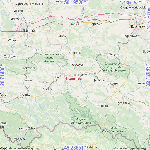
Trzcinica GPS coordinates[2]
49° 44' 34.836" North, 21° 25' 3" East
| Map corner | latitude | longitude |
|---|---|---|
| Upper-left | 50.19526°, | 20.71438° |
| Center: | 49.74301°, | 21.4175° |
| Lower-right: | 49.28651°, | 22.12063° |
| Map W x H: | 101×101 km | = 62.8×62.8mi |
| max Lat: | 54.83135° ⇑93.2% North |
| Trzcinica: | 49.74301° |
| min Lat: | ⇓6.8% South 49.21328° |
| min Long | Trzcinica | max Long |
| 14.20249° | 21.4175° | 24.03723° |
| W 78.2%⇐ | ⇒21.8% E |
Elevation
Elevation of Trzcinica is 250 m = 820 ft, and this is 58.6 m = 192 ft above average elevation for this country.
| Max E: |
974 m = 3196 ft | 24% |
| Trzcinica | 250 m 820 ft | |
| Avg. | 191.4 m = 628 ft | |
Min E: |
-3 m = -10 ft | 76% |
See also: Poland elevation on elevation.city.
Geographical zone
Trzcinica is located in North temperate zone (between Tropic of Cancer and the Arctic Circle). Distance of this North polar circle is 1870.3 km =1162.2 mi to North.| Distance of | km | miles | from Trzcinica |
|---|---|---|---|
| North Pole | 4476.2 | 2781.4 | to North |
| Arctic Circle | 1870.3 | 1162.2 | to North |
| Tropic Cancer | 2925 | 1817.5 | to South |
| Equator | 5530.9 | 3436.7 | to South |


Nearby cities:
15 places around Trzcinica: (largest is in red/bold)
• Biecz
11.1 km =6.9 mi,  265°
265°
• Binarowa
13.7 km =8.5 mi,  276°
276°
• Brzyska
9 km =5.6 mi,  347°
347°
• Dębowiec
7.3 km =4.5 mi,  154°
154°
• Jabłonica
8.6 km =5.3 mi,  311°
311°
• Jasło
4 km =2.5 mi,  86°
86°
• Korczyna
12.5 km =7.8 mi,  254°
254°
• Kołaczyce
7.3 km =4.5 mi,  9°
9°
• Lipinki
11.9 km =7.4 mi,  229°
229°
• Lipnica Dolna
5.1 km =3.2 mi,  331°
331°
• Osiek Jasielski
12.8 km =8 mi,  156°
156°
• Skołyszyn
5.9 km =3.7 mi, 277°
• Tarnowiec
11.5 km =7.1 mi,  96°
96°
• Wróblowa
5.4 km =3.4 mi, 346°
• Zarzecze
8.6 km =5.3 mi, 147°
Sources, notices
• [Note1] Compared only with cities in Poland existing in our database
• [Src1] Map data: © OpenStreetMap contributors (CC-BY-SA)
• [Src2] Other city data from geonames.org with taken over terms of usage.
• [Src3] Geographical zone / Annual Mean Temperature by Robert A. Rohde @ Wikipedia
