Skołyszyn geodata
Skołyszyn (Subcarpathian) is a seat of a third-order administrative division; located in Poland in Europe/Warsaw (GMT+2) time zone. With population of 1,455 people, there are 1909 cities with bigger population in this country. Compared to other cities in Poland, 93.1% of cities are located further ↑North; 77.3% of cities are located further ←West and 75.1% of cities have lower elevation than Skołyszyn. Note1


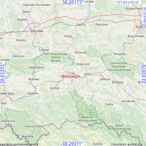
Skołyszyn GPS coordinates[2]
49° 44' 58.38" North, 21° 20' 11.94" East
| Map corner | latitude | longitude |
|---|---|---|
| Upper-left | 50.20173°, | 20.63353° |
| Center: | 49.74955°, | 21.33665° |
| Lower-right: | 49.29311°, | 22.03978° |
| Map W x H: | 101×101 km | = 62.8×62.8mi |
| max Lat: | 54.83135° ⇑93.1% North |
| Skołyszyn: | 49.74955° |
| min Lat: | ⇓6.9% South 49.21328° |
| min Long | Skołyszyn | max Long |
| 14.20249° | 21.33665° | 24.03723° |
| W 77.3%⇐ | ⇒22.7% E |
Elevation
Elevation of Skołyszyn is 247 m = 810 ft, and this is 55.6 m = 182 ft above average elevation for this country.
| Max E: |
974 m = 3196 ft | 24.9% |
| Skołyszyn | 247 m 810 ft | |
| Avg. | 191.4 m = 628 ft | |
Min E: |
-3 m = -10 ft | 75.1% |
See also: Poland elevation on elevation.city.
Geographical zone
Skołyszyn is located in North temperate zone (between Tropic of Cancer and the Arctic Circle). Distance of this North polar circle is 1869.5 km =1161.7 mi to North.| Distance of | km | miles | from Skołyszyn |
|---|---|---|---|
| North Pole | 4475.4 | 2780.9 | to North |
| Arctic Circle | 1869.5 | 1161.7 | to North |
| Tropic Cancer | 2925.7 | 1817.9 | to South |
| Equator | 5531.6 | 3437.2 | to South |


Nearby cities:
15 places around Skołyszyn: (largest is in red/bold)
• Biecz
5.5 km =3.4 mi,  254°
254°
• Binarowa
7.8 km =4.8 mi,  275°
275°
• Brzyska
8.9 km =5.5 mi,  25°
25°
• Dębowiec
11.5 km =7.1 mi,  129°
129°
• Jabłonica
5 km =3.1 mi,  352°
352°
• Jasło
9.8 km =6.1 mi,  92°
92°
• Korczyna
7.4 km =4.6 mi,  236°
236°
• Kołaczyce
9.5 km =5.9 mi,  47°
47°
• Lipinki
9.1 km =5.7 mi,  200°
200°
• Lipnica Dolna
5 km =3.1 mi,  42°
42°
• Ołpiny
11.4 km =7.1 mi,  303°
303°
• Racławice
10.6 km =6.6 mi,  269°
269°
• Szerzyny
9.3 km =5.8 mi,  315°
315°
• Trzcinica
5.9 km =3.7 mi,  97°
97°
• Wróblowa
6.4 km =4 mi, 45°
Sources, notices
• [Note1] Compared only with cities in Poland existing in our database
• [Src1] Map data: © OpenStreetMap contributors (CC-BY-SA)
• [Src2] Other city data from geonames.org with taken over terms of usage.
• [Src3] Geographical zone / Annual Mean Temperature by Robert A. Rohde @ Wikipedia
