Dębowiec geodata
Dębowiec (Subcarpathian) is a seat of a third-order administrative division; located in Poland in Europe/Warsaw (GMT+2) time zone. With population of 2,000 people, there are 1469 cities with bigger population in this country. Compared to other cities in Poland, 95% of cities are located further ↑North; 78.7% of cities are located further ←West and 83.9% of cities have lower elevation than Dębowiec. Note1


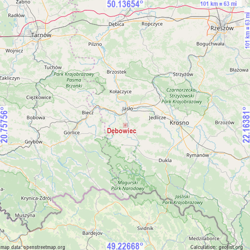
Dębowiec GPS coordinates[2]
49° 41' 1.464" North, 21° 27' 38.448" East
| Map corner | latitude | longitude |
|---|---|---|
| Upper-left | 50.13654°, | 20.75756° |
| Center: | 49.68374°, | 21.46068° |
| Lower-right: | 49.22668°, | 22.16381° |
| Map W x H: | 101.2×101.2 km | = 62.9×62.9mi |
| max Lat: | 54.83135° ⇑95% North |
| Dębowiec: | 49.68374° |
| min Lat: | ⇓5% South 49.21328° |
| min Long | Dębowiec | max Long |
| 14.20249° | 21.46068° | 24.03723° |
| W 78.7%⇐ | ⇒21.3% E |
Elevation
Elevation of Dębowiec is 285 m = 935 ft, and this is 93.6 m = 307 ft above average elevation for this country.
| Max E: |
974 m = 3196 ft | 16.1% |
| Dębowiec | 285 m 935 ft | |
| Avg. | 191.4 m = 628 ft | |
Min E: |
-3 m = -10 ft | 83.9% |
See also: Poland elevation on elevation.city.
Geographical zone
Dębowiec is located in North temperate zone (between Tropic of Cancer and the Arctic Circle). Distance of this North polar circle is 1876.9 km =1166.3 mi to North.| Distance of | km | miles | from Dębowiec |
|---|---|---|---|
| North Pole | 4482.7 | 2785.4 | to North |
| Arctic Circle | 1876.9 | 1166.3 | to North |
| Tropic Cancer | 2918.4 | 1813.4 | to South |
| Equator | 5524.3 | 3432.6 | to South |


Nearby cities:
15 places around Dębowiec: (largest is in red/bold)
• Biecz
15.4 km =9.6 mi,  292°
292°
• Jasło
6.9 km =4.3 mi,  7°
7°
• Jedlicze
14 km =8.7 mi,  74°
74°
• Korczyna
15.4 km =9.6 mi,  281°
281°
• Kołaczyce
13.9 km =8.6 mi,  352°
352°
• Lipinki
12.1 km =7.5 mi,  264°
264°
• Lipnica Dolna
12.4 km =7.7 mi,  333°
333°
• Nowy Żmigród
10 km =6.2 mi,  153°
153°
• Osiek Jasielski
5.5 km =3.4 mi,  158°
158°
• Pielgrzymka
7.7 km =4.8 mi,  191°
191°
• Skołyszyn
11.5 km =7.1 mi,  309°
309°
• Tarnowiec
9.9 km =6.2 mi,  57°
57°
• Trzcinica
7.3 km =4.5 mi, 334°
• Wróblowa
12.6 km =7.8 mi,  339°
339°
• Zarzecze
1.6 km =1 mi,  116°
116°
Sources, notices
• [Note1] Compared only with cities in Poland existing in our database
• [Src1] Map data: © OpenStreetMap contributors (CC-BY-SA)
• [Src2] Other city data from geonames.org with taken over terms of usage.
• [Src3] Geographical zone / Annual Mean Temperature by Robert A. Rohde @ Wikipedia
