Brzóza Stadnicka geodata
Brzóza Stadnicka (Subcarpathian) is a populated place; located in Poland in Europe/Warsaw (GMT+2) time zone. With population of 1,200 people, there are 2164 cities with bigger population in this country. Compared to other cities in Poland, 74.5% of cities are located further ↑North; 88.5% of cities are located further ←West and 66.7% of cities have lower elevation than Brzóza Stadnicka. Note1


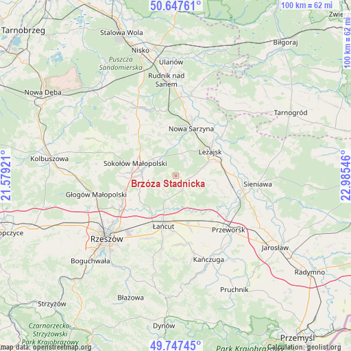
Brzóza Stadnicka GPS coordinates[2]
50° 11' 58.74" North, 22° 16' 56.388" East
| Map corner | latitude | longitude |
|---|---|---|
| Upper-left | 50.64761°, | 21.57921° |
| Center: | 50.19965°, | 22.28233° |
| Lower-right: | 49.74745°, | 22.98546° |
| Map W x H: | 100.1×100.1 km | = 62.2×62.2mi |
| max Lat: | 54.83135° ⇑74.5% North |
| Brzóza Stadnicka: | 50.19965° |
| min Lat: | ⇓25.5% South 49.21328° |
| min Long | Brzóza Stadnic | max Long |
| 14.20249° | 22.28233° | 24.03723° |
| W 88.5%⇐ | ⇒11.5% E |
Elevation
Elevation of Brzóza Stadnicka is 219 m = 719 ft, and this is 27.6 m = 91 ft above average elevation for this country.
| Max E: |
974 m = 3196 ft | 33.3% |
| Brzóza Stadnicka | 219 m 719 ft | |
| Avg. | 191.4 m = 628 ft | |
Min E: |
-3 m = -10 ft | 66.7% |
See also: Poland elevation on elevation.city.
Geographical zone
Brzóza Stadnicka is located in North temperate zone (between Tropic of Cancer and the Arctic Circle). Distance of this North polar circle is 1819.5 km =1130.6 mi to North.| Distance of | km | miles | from Brzóza Stadnicka |
|---|---|---|---|
| North Pole | 4425.4 | 2749.8 | to North |
| Arctic Circle | 1819.5 | 1130.6 | to North |
| Tropic Cancer | 2975.8 | 1849.1 | to South |
| Equator | 5581.7 | 3468.3 | to South |


Nearby cities:
15 places around Brzóza Stadnicka: (largest is in red/bold)
• Białobrzegi
11.1 km =6.9 mi,  166°
166°
• Brzóza Królewska
5.4 km =3.4 mi,  35°
35°
• Czarna
12.3 km =7.6 mi,  215°
215°
• Giedlarowa
9.3 km =5.8 mi,  70°
70°
• Grodzisko Górne
11.2 km =7 mi,  97°
97°
• Głuchów
13.1 km =8.1 mi,  183°
183°
• Hucisko
8.7 km =5.4 mi,  7°
7°
• Leżajsk
12 km =7.5 mi,  54°
54°
• Rakszawa
5.3 km =3.3 mi, 215°
• Sokołów Małopolski
12 km =7.5 mi,  285°
285°
• Wierzawice
12.7 km =7.9 mi, 71°
• Wola Żarczycka
10.4 km =6.5 mi,  347°
347°
• Wólka Grodziska
8.6 km =5.3 mi, 97°
• Wólka Niedźwiedzka
8.2 km =5.1 mi,  305°
305°
• Żołynia
4.6 km =2.9 mi,  156°
156°
Sources, notices
• [Note1] Compared only with cities in Poland existing in our database
• [Src1] Map data: © OpenStreetMap contributors (CC-BY-SA)
• [Src2] Other city data from geonames.org with taken over terms of usage.
• [Src3] Geographical zone / Annual Mean Temperature by Robert A. Rohde @ Wikipedia
