Hucisko geodata
Hucisko (Subcarpathian) is a populated place; located in Poland in Europe/Warsaw (GMT+2) time zone. With population of 662 people, there are 3139 cities with bigger population in this country. Compared to other cities in Poland, 72.6% of cities are located further ↑North; 88.7% of cities are located further ←West and 55.6% of cities have lower elevation than Hucisko. Note1


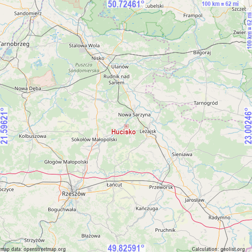
Hucisko GPS coordinates[2]
50° 16' 38.568" North, 22° 17' 57.588" East
| Map corner | latitude | longitude |
|---|---|---|
| Upper-left | 50.72461°, | 21.59621° |
| Center: | 50.27738°, | 22.29933° |
| Lower-right: | 49.82591°, | 23.00246° |
| Map W x H: | 99.9×99.9 km | = 62.1×62.1mi |
| max Lat: | 54.83135° ⇑72.6% North |
| Hucisko: | 50.27738° |
| min Lat: | ⇓27.4% South 49.21328° |
| min Long | Hucisko | max Long |
| 14.20249° | 22.29933° | 24.03723° |
| W 88.7%⇐ | ⇒11.3% E |
Elevation
Elevation of Hucisko is 187 m = 614 ft, and this is 4.4 m = 14 ft below average elevation for this country.
| Max E: |
974 m = 3196 ft | 44.4% |
| Avg. | 191.4 m = 628 ft | |
| Hucisko | 187 m = 614 ft | |
Min E: |
-3 m = -10 ft | 55.6% |
See also: Poland elevation on elevation.city.
Geographical zone
Hucisko is located in North temperate zone (between Tropic of Cancer and the Arctic Circle). Distance of this North polar circle is 1810.9 km =1125.2 mi to North.| Distance of | km | miles | from Hucisko |
|---|---|---|---|
| North Pole | 4416.7 | 2744.4 | to North |
| Arctic Circle | 1810.9 | 1125.2 | to North |
| Tropic Cancer | 2984.4 | 1854.4 | to South |
| Equator | 5590.3 | 3473.7 | to South |


Nearby cities:
15 places around Hucisko: (largest is in red/bold)
• Brzóza Królewska
4.6 km =2.9 mi,  156°
156°
• Brzóza Stadnicka
8.7 km =5.4 mi,  187°
187°
• Giedlarowa
9.4 km =5.8 mi,  126°
126°
• Górno
11 km =6.8 mi,  272°
272°
• Leżajsk
8.7 km =5.4 mi,  100°
100°
• Nowa Sarzyna
5.8 km =3.6 mi,  33°
33°
• Przychojec
7.6 km =4.7 mi,  72°
72°
• Stare Miasto
9.3 km =5.8 mi,  82°
82°
• Tarnogóra
10.2 km =6.3 mi,  7°
7°
• Wierzawice
11.7 km =7.3 mi,  113°
113°
• Wola Żarczycka
3.8 km =2.4 mi,  293°
293°
• Wólka Niedźwiedzka
8.8 km =5.5 mi,  243°
243°
• Wólka Łętowska
8.3 km =5.2 mi,  307°
307°
• Łukowa
7.3 km =4.5 mi,  43°
43°
• Łętownia
7 km =4.3 mi,  318°
318°
Sources, notices
• [Note1] Compared only with cities in Poland existing in our database
• [Src1] Map data: © OpenStreetMap contributors (CC-BY-SA)
• [Src2] Other city data from geonames.org with taken over terms of usage.
• [Src3] Geographical zone / Annual Mean Temperature by Robert A. Rohde @ Wikipedia
