Łukowa geodata
Łukowa (Subcarpathian) is a populated place; located in Poland in Europe/Warsaw (GMT+2) time zone. With population of 610 people, there are 3248 cities with bigger population in this country. Compared to other cities in Poland, 71.4% of cities are located further ↑North; 89.8% of cities are located further ←West and 52.5% of cities have higher elevation than Łukowa. Note1


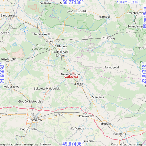
Łukowa GPS coordinates[2]
50° 19' 30.288" North, 22° 22' 12.18" East
| Map corner | latitude | longitude |
|---|---|---|
| Upper-left | 50.77186°, | 21.66693° |
| Center: | 50.32508°, | 22.37005° |
| Lower-right: | 49.87406°, | 23.07318° |
| Map W x H: | 99.8×99.8 km | = 62×62mi |
| max Lat: | 54.83135° ⇑71.4% North |
| Łukowa: | 50.32508° |
| min Lat: | ⇓28.6% South 49.21328° |
| min Long | Łukowa | max Long |
| 14.20249° | 22.37005° | 24.03723° |
| W 89.8%⇐ | ⇒10.2% E |
Elevation
Elevation of Łukowa is 165 m = 541 ft, and this is 26.4 m = 87 ft below average elevation for this country.
| Max E: |
974 m = 3196 ft | 52.5% |
| Avg. | 191.4 m = 628 ft | |
| Łukowa | 165 m = 541 ft | |
Min E: |
-3 m = -10 ft | 47.5% |
See also: Poland elevation on elevation.city.
Geographical zone
Łukowa is located in North temperate zone (between Tropic of Cancer and the Arctic Circle). Distance of this North polar circle is 1805.5 km =1121.9 mi to North.| Distance of | km | miles | from Łukowa |
|---|---|---|---|
| North Pole | 4411.4 | 2741.1 | to North |
| Arctic Circle | 1805.5 | 1121.9 | to North |
| Tropic Cancer | 2989.7 | 1857.7 | to South |
| Equator | 5595.6 | 3476.9 | to South |


Nearby cities:
15 places around Łukowa: (largest is in red/bold)
• Brzóza Królewska
10.1 km =6.3 mi,  198°
198°
• Bystre
6.2 km =3.9 mi,  17°
17°
• Giedlarowa
11.2 km =7 mi,  166°
166°
• Hucisko
7.3 km =4.5 mi,  223°
223°
• Krzeszów
9 km =5.6 mi,  347°
347°
• Kuryłówka
7.4 km =4.6 mi,  112°
112°
• Leżajsk
7.8 km =4.8 mi,  153°
153°
• Nowa Sarzyna
1.9 km =1.2 mi,  255°
255°
• Przychojec
3.7 km =2.3 mi,  143°
143°
• Stare Miasto
5.8 km =3.6 mi,  133°
133°
• Tarnogóra
6.1 km =3.8 mi,  322°
322°
• Wierzawice
11.4 km =7.1 mi, 149°
• Wola Żarczycka
9.3 km =5.8 mi,  246°
246°
• Wólka Łętowska
11.6 km =7.2 mi,  269°
269°
• Łętownia
9.7 km =6 mi, 269°
Sources, notices
• [Note1] Compared only with cities in Poland existing in our database
• [Src1] Map data: © OpenStreetMap contributors (CC-BY-SA)
• [Src2] Other city data from geonames.org with taken over terms of usage.
• [Src3] Geographical zone / Annual Mean Temperature by Robert A. Rohde @ Wikipedia
