Cegłów geodata
Cegłów (Mazovia) is a seat of a third-order administrative division; located in Poland in Europe/Warsaw (GMT+2) time zone. With population of 2,846 people, there are 1104 cities with bigger population in this country. Compared to other cities in Poland, 68.9% of cities are located further ↓South; 81.5% of cities are located further ←West and 51.9% of cities have higher elevation than Cegłów. Note1


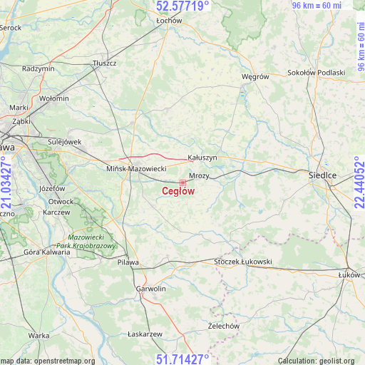
Cegłów GPS coordinates[2]
52° 8' 52.152" North, 21° 44' 14.604" East
| Map corner | latitude | longitude |
|---|---|---|
| Upper-left | 52.57719°, | 21.03427° |
| Center: | 52.14782°, | 21.73739° |
| Lower-right: | 51.71427°, | 22.44052° |
| Map W x H: | 95.9×95.9 km | = 59.6×59.6mi |
| max Lat: | 54.83135° ⇑31.1% North |
| Cegłów: | 52.14782° |
| min Lat: | ⇓68.9% South 49.21328° |
| min Long | Cegłów | max Long |
| 14.20249° | 21.73739° | 24.03723° |
| W 81.5%⇐ | ⇒18.5% E |
Elevation
Elevation of Cegłów is 167 m = 548 ft, and this is 24.4 m = 80 ft below average elevation for this country.
| Max E: |
974 m = 3196 ft | 51.9% |
| Avg. | 191.4 m = 628 ft | |
| Cegłów | 167 m = 548 ft | |
Min E: |
-3 m = -10 ft | 48.1% |
See also: Poland elevation on elevation.city.
Geographical zone
Cegłów is located in North temperate zone (between Tropic of Cancer and the Arctic Circle). Distance of this North polar circle is 1602.9 km =996 mi to North.| Distance of | km | miles | from Cegłów |
|---|---|---|---|
| North Pole | 4208.8 | 2615.2 | to North |
| Arctic Circle | 1602.9 | 996 | to North |
| Tropic Cancer | 3192.4 | 1983.7 | to South |
| Equator | 5798.3 | 3602.9 | to South |


Nearby cities:
15 places around Cegłów: (largest is in red/bold)
• Dobre
19.7 km =12.2 mi,  348°
348°
• Grębków
17.9 km =11.1 mi,  41°
41°
• Jakubów
8.9 km =5.5 mi,  334°
334°
• Kałuszyn
8.1 km =5 mi, 36°
• Kołbiel
19.8 km =12.3 mi,  242°
242°
• Latowicz
14.3 km =8.9 mi,  160°
160°
• Mińsk Mazowiecki
11.8 km =7.3 mi,  287°
287°
• Mrozy
4.9 km =3 mi,  65°
65°
• Parysów
19.5 km =12.1 mi,  191°
191°
• Pogorzel
10.9 km =6.8 mi,  249°
249°
• Siennica
10.2 km =6.3 mi,  232°
232°
• Wielgolas
12.9 km =8 mi,  181°
181°
• Wierzbno
19.9 km =12.4 mi,  24°
24°
• Wiśniew
12.3 km =7.6 mi,  355°
355°
• Wodynie
19.1 km =11.9 mi,  128°
128°
Sources, notices
• [Note1] Compared only with cities in Poland existing in our database
• [Src1] Map data: © OpenStreetMap contributors (CC-BY-SA)
• [Src2] Other city data from geonames.org with taken over terms of usage.
• [Src3] Geographical zone / Annual Mean Temperature by Robert A. Rohde @ Wikipedia
