Kałuszyn geodata
Kałuszyn (Mazovia) is a seat of a third-order administrative division; located in Poland in Europe/Warsaw (GMT+2) time zone. With population of 2,955 people, there are 1070 cities with bigger population in this country. Compared to other cities in Poland, 70.3% of cities are located further ↓South; 82.3% of cities are located further ←West and 52.6% of cities have lower elevation than Kałuszyn. Note1


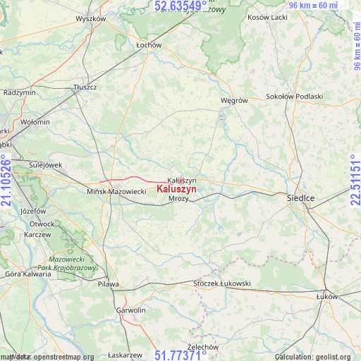
Kałuszyn GPS coordinates[2]
52° 12' 24.084" North, 21° 48' 30.168" East
| Map corner | latitude | longitude |
|---|---|---|
| Upper-left | 52.63549°, | 21.10526° |
| Center: | 52.20669°, | 21.80838° |
| Lower-right: | 51.77371°, | 22.51151° |
| Map W x H: | 95.8×95.8 km | = 59.5×59.5mi |
| max Lat: | 54.83135° ⇑29.7% North |
| Kałuszyn: | 52.20669° |
| min Lat: | ⇓70.3% South 49.21328° |
| min Long | Kałuszyn | max Long |
| 14.20249° | 21.80838° | 24.03723° |
| W 82.3%⇐ | ⇒17.7% E |
Elevation
Elevation of Kałuszyn is 179 m = 587 ft, and this is 12.4 m = 41 ft below average elevation for this country.
| Max E: |
974 m = 3196 ft | 47.4% |
| Avg. | 191.4 m = 628 ft | |
| Kałuszyn | 179 m = 587 ft | |
Min E: |
-3 m = -10 ft | 52.6% |
See also: Poland elevation on elevation.city.
Geographical zone
Kałuszyn is located in North temperate zone (between Tropic of Cancer and the Arctic Circle). Distance of this North polar circle is 1596.3 km =991.9 mi to North.| Distance of | km | miles | from Kałuszyn |
|---|---|---|---|
| North Pole | 4202.2 | 2611.1 | to North |
| Arctic Circle | 1596.3 | 991.9 | to North |
| Tropic Cancer | 3198.9 | 1987.7 | to South |
| Equator | 5804.8 | 3606.9 | to South |


Nearby cities:
15 places around Kałuszyn: (largest is in red/bold)
• Cegłów
8.1 km =5 mi,  216°
216°
• Dobre
15.5 km =9.6 mi,  325°
325°
• Grębków
9.8 km =6.1 mi,  44°
44°
• Jakubów
8.8 km =5.5 mi,  279°
279°
• Kotuń
18 km =11.2 mi,  100°
100°
• Latowicz
20.1 km =12.5 mi,  180°
180°
• Mińsk Mazowiecki
16.4 km =10.2 mi,  259°
259°
• Mrozy
4.5 km =2.8 mi, 184°
• Pogorzel
18.3 km =11.4 mi,  235°
235°
• Siennica
18.2 km =11.3 mi,  225°
225°
• Stanisławów
19.9 km =12.4 mi,  297°
297°
• Wielgolas
20.1 km =12.5 mi,  194°
194°
• Wierzbno
12 km =7.5 mi,  16°
16°
• Wiśniew
8.1 km =5 mi,  315°
315°
• Wodynie
21 km =13 mi,  151°
151°
Sources, notices
• [Note1] Compared only with cities in Poland existing in our database
• [Src1] Map data: © OpenStreetMap contributors (CC-BY-SA)
• [Src2] Other city data from geonames.org with taken over terms of usage.
• [Src3] Geographical zone / Annual Mean Temperature by Robert A. Rohde @ Wikipedia
