Brzeziny geodata
Brzeziny (Świętokrzyskie) is a populated place; located in Poland in Europe/Warsaw (GMT+2) time zone. With population of 2,015 people, there are 1459 cities with bigger population in this country. Compared to other cities in Poland, 60.8% of cities are located further ↑North; 66% of cities are located further ←West and 74.2% of cities have lower elevation than Brzeziny. Note1


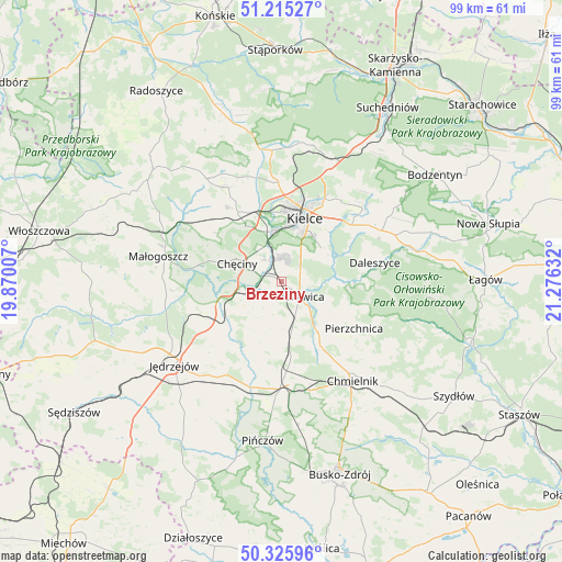
Brzeziny GPS coordinates[2]
50° 46' 21.828" North, 20° 34' 23.484" East
| Map corner | latitude | longitude |
|---|---|---|
| Upper-left | 51.21527°, | 19.87007° |
| Center: | 50.77273°, | 20.57319° |
| Lower-right: | 50.32596°, | 21.27632° |
| Map W x H: | 98.9×98.9 km | = 61.5×61.5mi |
| max Lat: | 54.83135° ⇑60.8% North |
| Brzeziny: | 50.77273° |
| min Lat: | ⇓39.2% South 49.21328° |
| min Long | Brzeziny | max Long |
| 14.20249° | 20.57319° | 24.03723° |
| W 66%⇐ | ⇒34% E |
Elevation
Elevation of Brzeziny is 243 m = 797 ft, and this is 51.6 m = 169 ft above average elevation for this country.
| Max E: |
974 m = 3196 ft | 25.8% |
| Brzeziny | 243 m 797 ft | |
| Avg. | 191.4 m = 628 ft | |
Min E: |
-3 m = -10 ft | 74.2% |
See also: Poland elevation on elevation.city.
Geographical zone
Brzeziny is located in North temperate zone (between Tropic of Cancer and the Arctic Circle). Distance of this North polar circle is 1755.8 km =1091 mi to North.| Distance of | km | miles | from Brzeziny |
|---|---|---|---|
| North Pole | 4361.7 | 2710.2 | to North |
| Arctic Circle | 1755.8 | 1091 | to North |
| Tropic Cancer | 3039.5 | 1888.7 | to South |
| Equator | 5645.4 | 3507.9 | to South |


Nearby cities:
15 places around Brzeziny: (largest is in red/bold)
• Chęciny
8.4 km =5.2 mi,  291°
291°
• Daleszyce
16.8 km =10.4 mi,  78°
78°
• Domaszowice
13.7 km =8.5 mi,  34°
34°
• Kielce
11.5 km =7.1 mi,  19°
19°
• Korytnica
13.4 km =8.3 mi,  197°
197°
• Kostomłoty Drugie
17.1 km =10.6 mi,  358°
358°
• Kostomłoty Pierwsze
16.8 km =10.4 mi,  5°
5°
• Masłów
17.7 km =11 mi,  36°
36°
• Morawica
4.3 km =2.7 mi,  132°
132°
• Osiedle-Nowiny
5.5 km =3.4 mi,  335°
335°
• Piekoszów
14.2 km =8.8 mi,  327°
327°
• Pierzchnica
15.3 km =9.5 mi,  123°
123°
• Siedlce
6.5 km =4 mi,  240°
240°
• Sobków
11.8 km =7.3 mi,  226°
226°
• Łukowa
5.8 km =3.6 mi, 204°
Sources, notices
• [Note1] Compared only with cities in Poland existing in our database
• [Src1] Map data: © OpenStreetMap contributors (CC-BY-SA)
• [Src2] Other city data from geonames.org with taken over terms of usage.
• [Src3] Geographical zone / Annual Mean Temperature by Robert A. Rohde @ Wikipedia
