Daleszyce geodata
Daleszyce (Świętokrzyskie) is a seat of a third-order administrative division; located in Poland in Europe/Warsaw (GMT+2) time zone. With population of 2,932 people, there are 1078 cities with bigger population in this country. Compared to other cities in Poland, 60.1% of cities are located further ↑North; 69.2% of cities are located further ←West and 79.2% of cities have lower elevation than Daleszyce. Note1


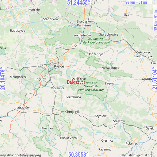
Daleszyce GPS coordinates[2]
50° 48' 8.244" North, 20° 48' 28.476" East
| Map corner | latitude | longitude |
|---|---|---|
| Upper-left | 51.24455°, | 20.10479° |
| Center: | 50.80229°, | 20.80791° |
| Lower-right: | 50.3558°, | 21.51104° |
| Map W x H: | 98.8×98.8 km | = 61.4×61.4mi |
| max Lat: | 54.83135° ⇑60.1% North |
| Daleszyce: | 50.80229° |
| min Lat: | ⇓39.9% South 49.21328° |
| min Long | Daleszyce | max Long |
| 14.20249° | 20.80791° | 24.03723° |
| W 69.2%⇐ | ⇒30.8% E |
Elevation
Elevation of Daleszyce is 262 m = 860 ft, and this is 70.6 m = 232 ft above average elevation for this country.
| Max E: |
974 m = 3196 ft | 20.8% |
| Daleszyce | 262 m 860 ft | |
| Avg. | 191.4 m = 628 ft | |
Min E: |
-3 m = -10 ft | 79.2% |
See also: Poland elevation on elevation.city.
Geographical zone
Daleszyce is located in North temperate zone (between Tropic of Cancer and the Arctic Circle). Distance of this North polar circle is 1752.5 km =1089 mi to North.| Distance of | km | miles | from Daleszyce |
|---|---|---|---|
| North Pole | 4358.4 | 2708.2 | to North |
| Arctic Circle | 1752.5 | 1089 | to North |
| Tropic Cancer | 3042.8 | 1890.7 | to South |
| Equator | 5648.7 | 3509.9 | to South |


Nearby cities:
15 places around Daleszyce: (largest is in red/bold)
• Bieliny
10.7 km =6.6 mi,  60°
60°
• Bodzentyn
18.7 km =11.6 mi,  34°
34°
• Brzeziny
16.8 km =10.4 mi,  258°
258°
• Domaszowice
11.9 km =7.4 mi,  312°
312°
• Górno
5.2 km =3.2 mi,  13°
13°
• Gózd
20.4 km =12.7 mi,  351°
351°
• Kielce
14.8 km =9.2 mi,  300°
300°
• Kostomłoty Pierwsze
20.1 km =12.5 mi, 311°
• Masłów
12.4 km =7.7 mi,  331°
331°
• Morawica
14.7 km =9.1 mi,  245°
245°
• Osiedle-Nowiny
18.8 km =11.7 mi,  275°
275°
• Pierzchnica
12.2 km =7.6 mi,  197°
197°
• Wiśniowa
19.8 km =12.3 mi,  88°
88°
• Wola Jachowa
5.9 km =3.7 mi,  36°
36°
• Łagów
19.7 km =12.2 mi,  98°
98°
Sources, notices
• [Note1] Compared only with cities in Poland existing in our database
• [Src1] Map data: © OpenStreetMap contributors (CC-BY-SA)
• [Src2] Other city data from geonames.org with taken over terms of usage.
• [Src3] Geographical zone / Annual Mean Temperature by Robert A. Rohde @ Wikipedia
