Otwock geodata
Otwock (Mazovia) is a seat of a third-order administrative division; located in Poland in Europe/Warsaw (GMT+2) time zone. With population of 43,388 people, there are 119 cities with bigger population in this country. Compared to other cities in Poland, 68% of cities are located further ↓South; 76.6% of cities are located further ←West and 82.7% of cities have higher elevation than Otwock. Note1


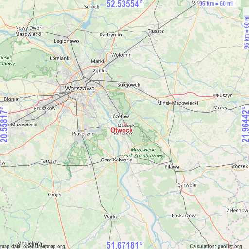
Otwock GPS coordinates[2]
52° 6' 20.772" North, 21° 15' 40.644" East
| Map corner | latitude | longitude |
|---|---|---|
| Upper-left | 52.53554°, | 20.55817° |
| Center: | 52.10577°, | 21.26129° |
| Lower-right: | 51.67181°, | 21.96442° |
| Map W x H: | 96×96 km | = 59.7×59.7mi |
| max Lat: | 54.83135° ⇑32% North |
| Otwock: | 52.10577° |
| min Lat: | ⇓68% South 49.21328° |
| min Long | Otwock | max Long |
| 14.20249° | 21.26129° | 24.03723° |
| W 76.6%⇐ | ⇒23.4% E |
Elevation
Elevation of Otwock is 94 m = 308 ft, and this is 97.4 m = 320 ft below average elevation for this country.
| Max E: |
974 m = 3196 ft | 82.7% |
| Avg. | 191.4 m = 628 ft | |
| Otwock | 94 m = 308 ft | |
Min E: |
-3 m = -10 ft | 17.3% |
See also: Otwock elevation on elevation.city.
Geographical zone
Otwock is located in North temperate zone (between Tropic of Cancer and the Arctic Circle). Distance of this North polar circle is 1607.6 km =998.9 mi to North.| Distance of | km | miles | from Otwock |
|---|---|---|---|
| North Pole | 4213.4 | 2618.1 | to North |
| Arctic Circle | 1607.6 | 998.9 | to North |
| Tropic Cancer | 3187.7 | 1980.7 | to South |
| Equator | 5793.6 | 3600 | to South |


Nearby cities:
15 places around Otwock: (largest is in red/bold)
• Baniocha
12.9 km =8 mi,  219°
219°
• Bielawa
8.9 km =5.5 mi,  272°
272°
• Celestynów
10.2 km =6.3 mi,  119°
119°
• Chylice
13.9 km =8.6 mi,  257°
257°
• Chyliczki
13.3 km =8.3 mi, 260°
• Czarnów
12.5 km =7.8 mi,  243°
243°
• Góra Kalwaria
14.7 km =9.1 mi,  192°
192°
• Józefosław
14.7 km =9.1 mi, 267°
• Józefów
3.9 km =2.4 mi,  333°
333°
• Kabaty
12.6 km =7.8 mi,  282°
282°
• Karczew
3.3 km =2.1 mi, 193°
• Konstancin-Jeziorna
9.9 km =6.2 mi, 262°
• Wawer
11.6 km =7.2 mi, 330°
• Wilanów
13.5 km =8.4 mi,  298°
298°
• Wiązowna
7.5 km =4.7 mi,  15°
15°
Sources, notices
• [Note1] Compared only with cities in Poland existing in our database
• [Src1] Map data: © OpenStreetMap contributors (CC-BY-SA)
• [Src2] Other city data from geonames.org with taken over terms of usage.
• [Src3] Geographical zone / Annual Mean Temperature by Robert A. Rohde @ Wikipedia
