Wiązowna geodata
Wiązowna (Mazovia) is a populated place; located in Poland in Europe/Warsaw (GMT+2) time zone. With population of 980 people, there are 2532 cities with bigger population in this country. Compared to other cities in Poland, 69.3% of cities are located further ↓South; 76.8% of cities are located further ←West and 79.8% of cities have higher elevation than Wiązowna. Note1


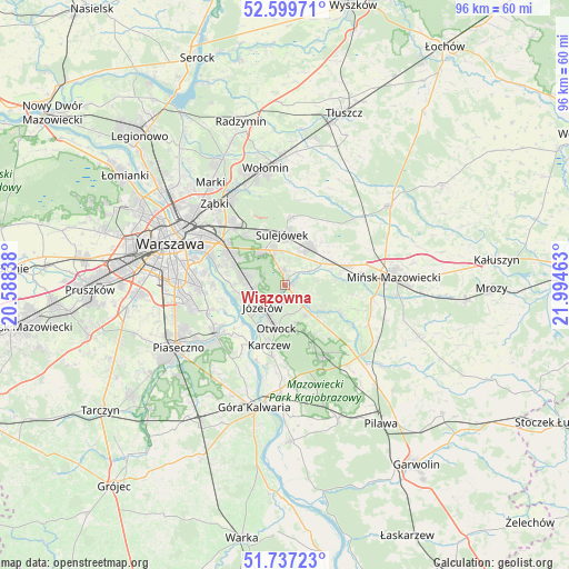
Wiązowna GPS coordinates[2]
52° 10' 14.016" North, 21° 17' 29.4" East
| Map corner | latitude | longitude |
|---|---|---|
| Upper-left | 52.59971°, | 20.58838° |
| Center: | 52.17056°, | 21.2915° |
| Lower-right: | 51.73723°, | 21.99463° |
| Map W x H: | 95.9×95.9 km | = 59.6×59.6mi |
| max Lat: | 54.83135° ⇑30.7% North |
| Wiązowna: | 52.17056° |
| min Lat: | ⇓69.3% South 49.21328° |
| min Long | Wiązowna | max Long |
| 14.20249° | 21.2915° | 24.03723° |
| W 76.8%⇐ | ⇒23.2% E |
Elevation
Elevation of Wiązowna is 100 m = 328 ft, and this is 91.4 m = 300 ft below average elevation for this country.
| Max E: |
974 m = 3196 ft | 79.8% |
| Avg. | 191.4 m = 628 ft | |
| Wiązowna | 100 m = 328 ft | |
Min E: |
-3 m = -10 ft | 20.2% |
See also: Poland elevation on elevation.city.
Geographical zone
Wiązowna is located in North temperate zone (between Tropic of Cancer and the Arctic Circle). Distance of this North polar circle is 1600.4 km =994.4 mi to North.| Distance of | km | miles | from Wiązowna |
|---|---|---|---|
| North Pole | 4206.2 | 2613.6 | to North |
| Arctic Circle | 1600.4 | 994.4 | to North |
| Tropic Cancer | 3194.9 | 1985.2 | to South |
| Equator | 5800.8 | 3604.4 | to South |


Nearby cities:
15 places around Wiązowna: (largest is in red/bold)
• Bielawa
12.9 km =8 mi,  237°
237°
• Celestynów
14 km =8.7 mi,  150°
150°
• Dębe Wielkie
10.8 km =6.7 mi,  72°
72°
• Halinów
7.8 km =4.8 mi,  33°
33°
• Józefów
5.3 km =3.3 mi,  225°
225°
• Kabaty
15 km =9.3 mi,  252°
252°
• Karczew
10.8 km =6.7 mi,  195°
195°
• Konstancin-Jeziorna
14.6 km =9.1 mi, 234°
• Otwock
7.5 km =4.7 mi, 195°
• Praga Południe
16.3 km =10.1 mi,  300°
300°
• Rembertów
13.3 km =8.3 mi,  318°
318°
• Sulejówek
9.2 km =5.7 mi,  350°
350°
• Wawer
8.3 km =5.2 mi,  290°
290°
• Wesoła
10.4 km =6.5 mi,  333°
333°
• Wilanów
13.9 km =8.6 mi,  266°
266°
Sources, notices
• [Note1] Compared only with cities in Poland existing in our database
• [Src1] Map data: © OpenStreetMap contributors (CC-BY-SA)
• [Src2] Other city data from geonames.org with taken over terms of usage.
• [Src3] Geographical zone / Annual Mean Temperature by Robert A. Rohde @ Wikipedia
