Józefów geodata
Józefów (Mazovia) is a seat of a third-order administrative division; located in Poland in Europe/Warsaw (GMT+2) time zone. With population of 17,910 people, there are 276 cities with bigger population in this country. Compared to other cities in Poland, 68.5% of cities are located further ↓South; 76.2% of cities are located further ←West and 83.2% of cities have higher elevation than Józefów. Note1


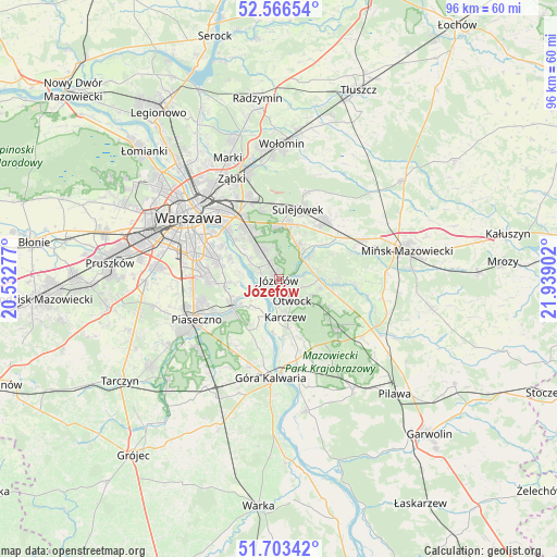
Józefów GPS coordinates[2]
52° 8' 13.452" North, 21° 14' 9.204" East
| Map corner | latitude | longitude |
|---|---|---|
| Upper-left | 52.56654°, | 20.53277° |
| Center: | 52.13707°, | 21.23589° |
| Lower-right: | 51.70342°, | 21.93902° |
| Map W x H: | 96×96 km | = 59.7×59.7mi |
| max Lat: | 54.83135° ⇑31.5% North |
| Józefów: | 52.13707° |
| min Lat: | ⇓68.5% South 49.21328° |
| min Long | Józefów | max Long |
| 14.20249° | 21.23589° | 24.03723° |
| W 76.2%⇐ | ⇒23.8% E |
Elevation
Elevation of Józefów is 93 m = 305 ft, and this is 98.4 m = 323 ft below average elevation for this country.
| Max E: |
974 m = 3196 ft | 83.2% |
| Avg. | 191.4 m = 628 ft | |
| Józefów | 93 m = 305 ft | |
Min E: |
-3 m = -10 ft | 16.8% |
See also: Poland elevation on elevation.city.
Geographical zone
Józefów is located in North temperate zone (between Tropic of Cancer and the Arctic Circle). Distance of this North polar circle is 1604.1 km =996.7 mi to North.| Distance of | km | miles | from Józefów |
|---|---|---|---|
| North Pole | 4210 | 2616 | to North |
| Arctic Circle | 1604.1 | 996.7 | to North |
| Tropic Cancer | 3191.2 | 1982.9 | to South |
| Equator | 5797.1 | 3602.1 | to South |


Nearby cities:
15 places around Józefów: (largest is in red/bold)
• Bielawa
7.8 km =4.8 mi,  246°
246°
• Chylice
13.5 km =8.4 mi,  241°
241°
• Chyliczki
12.7 km =7.9 mi, 243°
• Czarnów
13 km =8.1 mi,  226°
226°
• Halinów
13 km =8.1 mi,  38°
38°
• Kabaty
10.6 km =6.6 mi,  265°
265°
• Karczew
6.8 km =4.2 mi,  172°
172°
• Konstancin-Jeziorna
9.4 km =5.8 mi, 239°
• Otwock
3.9 km =2.4 mi,  153°
153°
• Sulejówek
13 km =8.1 mi,  10°
10°
• Ursynów
12.7 km =7.9 mi,  276°
276°
• Wawer
7.7 km =4.8 mi,  328°
328°
• Wesoła
13.1 km =8.1 mi,  356°
356°
• Wilanów
10.5 km =6.5 mi,  285°
285°
• Wiązowna
5.3 km =3.3 mi,  45°
45°
Sources, notices
• [Note1] Compared only with cities in Poland existing in our database
• [Src1] Map data: © OpenStreetMap contributors (CC-BY-SA)
• [Src2] Other city data from geonames.org with taken over terms of usage.
• [Src3] Geographical zone / Annual Mean Temperature by Robert A. Rohde @ Wikipedia
