Celestynów geodata
Celestynów (Mazovia) is a seat of a third-order administrative division; located in Poland in Europe/Warsaw (GMT+2) time zone. With population of 4,007 people, there are 813 cities with bigger population in this country. Compared to other cities in Poland, 66.7% of cities are located further ↓South; 78% of cities are located further ←West and 64.4% of cities have higher elevation than Celestynów. Note1


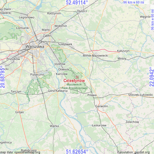
Celestynów GPS coordinates[2]
52° 3' 39.348" North, 21° 23' 27.852" East
| Map corner | latitude | longitude |
|---|---|---|
| Upper-left | 52.49114°, | 20.68795° |
| Center: | 52.06093°, | 21.39107° |
| Lower-right: | 51.62654°, | 22.0942° |
| Map W x H: | 96.1×96.1 km | = 59.7×59.7mi |
| max Lat: | 54.83135° ⇑33.3% North |
| Celestynów: | 52.06093° |
| min Lat: | ⇓66.7% South 49.21328° |
| min Long | Celestynów | max Long |
| 14.20249° | 21.39107° | 24.03723° |
| W 78%⇐ | ⇒22% E |
Elevation
Elevation of Celestynów is 135 m = 443 ft, and this is 56.4 m = 185 ft below average elevation for this country.
| Max E: |
974 m = 3196 ft | 64.4% |
| Avg. | 191.4 m = 628 ft | |
| Celestynów | 135 m = 443 ft | |
Min E: |
-3 m = -10 ft | 35.6% |
See also: Poland elevation on elevation.city.
Geographical zone
Celestynów is located in North temperate zone (between Tropic of Cancer and the Arctic Circle). Distance of this North polar circle is 1612.5 km =1002 mi to North.| Distance of | km | miles | from Celestynów |
|---|---|---|---|
| North Pole | 4218.4 | 2621.2 | to North |
| Arctic Circle | 1612.5 | 1002 | to North |
| Tropic Cancer | 3182.7 | 1977.6 | to South |
| Equator | 5788.6 | 3596.9 | to South |


Nearby cities:
15 places around Celestynów: (largest is in red/bold)
• Baniocha
17.9 km =11.1 mi,  253°
253°
• Czersk
15.8 km =9.8 mi,  223°
223°
• Dębe Wielkie
15.8 km =9.8 mi,  13°
13°
• Góra Kalwaria
15.3 km =9.5 mi,  232°
232°
• Józefów
13.6 km =8.5 mi,  308°
308°
• Karczew
9.8 km =6.1 mi,  280°
280°
• Kołbiel
6.2 km =3.9 mi,  86°
86°
• Mińsk Mazowiecki
18.1 km =11.2 mi,  43°
43°
• Osieck
10.7 km =6.6 mi,  169°
169°
• Otwock
10.2 km =6.3 mi,  299°
299°
• Pilawa
14.8 km =9.2 mi,  139°
139°
• Pogorzel
14.6 km =9.1 mi,  66°
66°
• Siennica
16 km =9.9 mi,  77°
77°
• Sobienie Jeziory
15.5 km =9.6 mi,  202°
202°
• Wiązowna
14 km =8.7 mi,  330°
330°
Sources, notices
• [Note1] Compared only with cities in Poland existing in our database
• [Src1] Map data: © OpenStreetMap contributors (CC-BY-SA)
• [Src2] Other city data from geonames.org with taken over terms of usage.
• [Src3] Geographical zone / Annual Mean Temperature by Robert A. Rohde @ Wikipedia
