Myszyniec geodata
Myszyniec (Mazovia) is a seat of a third-order administrative division; located in Poland in Europe/Warsaw (GMT+2) time zone. With population of 2,980 people, there are 1061 cities with bigger population in this country. Compared to other cities in Poland, 88.3% of cities are located further ↓South; 77.5% of cities are located further ←West and 68.6% of cities have higher elevation than Myszyniec. Note1


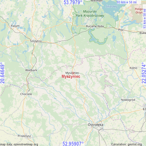
Myszyniec GPS coordinates[2]
53° 22' 49.98" North, 21° 20' 58.596" East
| Map corner | latitude | longitude |
|---|---|---|
| Upper-left | 53.7979°, | 20.64649° |
| Center: | 53.38055°, | 21.34961° |
| Lower-right: | 52.95907°, | 22.05274° |
| Map W x H: | 93.3×93.3 km | = 58×58mi |
| max Lat: | 54.83135° ⇑11.7% North |
| Myszyniec: | 53.38055° |
| min Lat: | ⇓88.3% South 49.21328° |
| min Long | Myszyniec | max Long |
| 14.20249° | 21.34961° | 24.03723° |
| W 77.5%⇐ | ⇒22.5% E |
Elevation
Elevation of Myszyniec is 124 m = 407 ft, and this is 67.4 m = 221 ft below average elevation for this country.
| Max E: |
974 m = 3196 ft | 68.6% |
| Avg. | 191.4 m = 628 ft | |
| Myszyniec | 124 m = 407 ft | |
Min E: |
-3 m = -10 ft | 31.4% |
See also: Poland elevation on elevation.city.
Geographical zone
Myszyniec is located in North temperate zone (between Tropic of Cancer and the Arctic Circle). Distance of this North polar circle is 1465.8 km =910.8 mi to North.| Distance of | km | miles | from Myszyniec |
|---|---|---|---|
| North Pole | 4071.7 | 2530 | to North |
| Arctic Circle | 1465.8 | 910.8 | to North |
| Tropic Cancer | 3329.4 | 2068.8 | to South |
| Equator | 5935.4 | 3688.1 | to South |


Nearby cities:
15 places around Myszyniec: (largest is in red/bold)
• Baranowo
23.1 km =14.4 mi,  188°
188°
• Chorzele
32.9 km =20.4 mi,  246°
246°
• Czarnia
10.6 km =6.6 mi,  255°
255°
• Jednorożec
33.2 km =20.6 mi,  216°
216°
• Kadzidło
18 km =11.2 mi,  154°
154°
• Lelis
26.1 km =16.2 mi, 147°
• Olszewo Borki
36.9 km =22.9 mi,  160°
160°
• Ostrołęka
36 km =22.4 mi, 155°
• Rozogi
11.7 km =7.3 mi,  4°
4°
• Ruciane-Nida
31.6 km =19.6 mi,  23°
23°
• Szczytno
31.4 km =19.5 mi,  310°
310°
• Wielbark
26.8 km =16.7 mi,  274°
274°
• Zbójna
32.9 km =20.4 mi,  117°
117°
• Łyse
14.4 km =8.9 mi,  97°
97°
• Świętajno
22.5 km =14 mi,  336°
336°
Sources, notices
• [Note1] Compared only with cities in Poland existing in our database
• [Src1] Map data: © OpenStreetMap contributors (CC-BY-SA)
• [Src2] Other city data from geonames.org with taken over terms of usage.
• [Src3] Geographical zone / Annual Mean Temperature by Robert A. Rohde @ Wikipedia
