Łyse geodata
Łyse (Mazovia) is a seat of a third-order administrative division; located in Poland in Europe/Warsaw (GMT+2) time zone. With population of 2,350 people, there are 1302 cities with bigger population in this country. Compared to other cities in Poland, 88.2% of cities are located further ↓South; 79.7% of cities are located further ←West and 71.1% of cities have higher elevation than Łyse. Note1


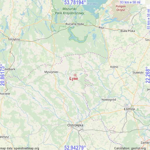
Łyse GPS coordinates[2]
53° 21' 51.948" North, 21° 33' 53.532" East
| Map corner | latitude | longitude |
|---|---|---|
| Upper-left | 53.78194°, | 20.86175° |
| Center: | 53.36443°, | 21.56487° |
| Lower-right: | 52.94279°, | 22.268° |
| Map W x H: | 93.3×93.3 km | = 58×58mi |
| max Lat: | 54.83135° ⇑11.8% North |
| Łyse: | 53.36443° |
| min Lat: | ⇓88.2% South 49.21328° |
| min Long | Łyse | max Long |
| 14.20249° | 21.56487° | 24.03723° |
| W 79.7%⇐ | ⇒20.3% E |
Elevation
Elevation of Łyse is 119 m = 390 ft, and this is 72.4 m = 238 ft below average elevation for this country.
| Max E: |
974 m = 3196 ft | 71.1% |
| Avg. | 191.4 m = 628 ft | |
| Łyse | 119 m = 390 ft | |
Min E: |
-3 m = -10 ft | 28.9% |
See also: Poland elevation on elevation.city.
Geographical zone
Łyse is located in North temperate zone (between Tropic of Cancer and the Arctic Circle). Distance of this North polar circle is 1467.6 km =911.9 mi to North.| Distance of | km | miles | from Łyse |
|---|---|---|---|
| North Pole | 4073.5 | 2531.2 | to North |
| Arctic Circle | 1467.6 | 911.9 | to North |
| Tropic Cancer | 3327.6 | 2067.7 | to South |
| Equator | 5933.6 | 3687 | to South |


Nearby cities:
15 places around Łyse: (largest is in red/bold)
• Baranowo
27.5 km =17.1 mi,  220°
220°
• Czarnia
24.5 km =15.2 mi,  267°
267°
• Janowo
23.4 km =14.5 mi,  93°
93°
• Kadzidło
15.9 km =9.9 mi,  204°
204°
• Kolno
24.7 km =15.3 mi,  77°
77°
• Lelis
20.3 km =12.6 mi,  181°
181°
• Mały Płock
31.5 km =19.6 mi,  102°
102°
• Miastkowo
29 km =18 mi,  144°
144°
• Myszyniec
14.4 km =8.9 mi,  277°
277°
• Nowogród
26 km =16.2 mi,  125°
125°
• Ostrołęka
30.9 km =19.2 mi, 178°
• Rozogi
19 km =11.8 mi,  315°
315°
• Ruciane-Nida
30.9 km =19.2 mi,  356°
356°
• Zbójna
20.1 km =12.5 mi, 132°
• Świętajno
32.3 km =20.1 mi,  314°
314°
Sources, notices
• [Note1] Compared only with cities in Poland existing in our database
• [Src1] Map data: © OpenStreetMap contributors (CC-BY-SA)
• [Src2] Other city data from geonames.org with taken over terms of usage.
• [Src3] Geographical zone / Annual Mean Temperature by Robert A. Rohde @ Wikipedia
