Jednorożec geodata
Jednorożec (Mazovia) is a seat of a third-order administrative division; located in Poland in Europe/Warsaw (GMT+2) time zone. With population of 1,800 people, there are 1605 cities with bigger population in this country. Compared to other cities in Poland, 85.4% of cities are located further ↓South; 73.6% of cities are located further ←West and 72.1% of cities have higher elevation than Jednorożec. Note1


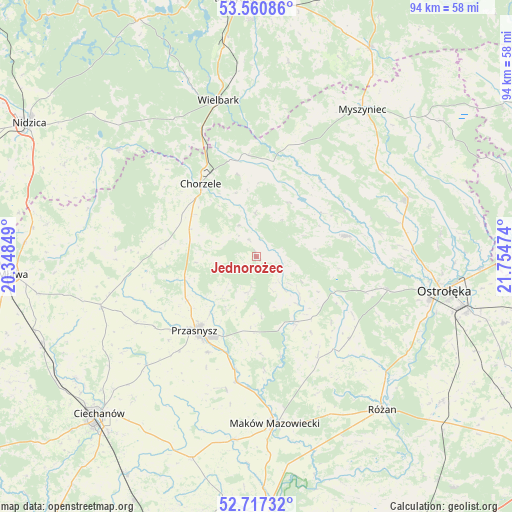
Jednorożec GPS coordinates[2]
53° 8' 28.176" North, 21° 3' 5.796" East
| Map corner | latitude | longitude |
|---|---|---|
| Upper-left | 53.56086°, | 20.34849° |
| Center: | 53.14116°, | 21.05161° |
| Lower-right: | 52.71732°, | 21.75474° |
| Map W x H: | 93.8×93.8 km | = 58.3×58.3mi |
| max Lat: | 54.83135° ⇑14.6% North |
| Jednorożec: | 53.14116° |
| min Lat: | ⇓85.4% South 49.21328° |
| min Long | Jednorożec | max Long |
| 14.20249° | 21.05161° | 24.03723° |
| W 73.6%⇐ | ⇒26.4% E |
Elevation
Elevation of Jednorożec is 117 m = 384 ft, and this is 74.4 m = 244 ft below average elevation for this country.
| Max E: |
974 m = 3196 ft | 72.1% |
| Avg. | 191.4 m = 628 ft | |
| Jednorożec | 117 m = 384 ft | |
Min E: |
-3 m = -10 ft | 27.9% |
See also: Poland elevation on elevation.city.
Geographical zone
Jednorożec is located in North temperate zone (between Tropic of Cancer and the Arctic Circle). Distance of this North polar circle is 1492.4 km =927.3 mi to North.| Distance of | km | miles | from Jednorożec |
|---|---|---|---|
| North Pole | 4098.3 | 2546.6 | to North |
| Arctic Circle | 1492.4 | 927.3 | to North |
| Tropic Cancer | 3302.8 | 2052.3 | to South |
| Equator | 5908.7 | 3671.5 | to South |


Nearby cities:
15 places around Jednorożec: (largest is in red/bold)
• Baranowo
16.9 km =10.5 mi,  76°
76°
• Chorzele
16.8 km =10.4 mi,  322°
322°
• Czarnia
25.7 km =16 mi,  21°
21°
• Czernice Borowe
25.3 km =15.7 mi,  241°
241°
• Czerwonka
29.7 km =18.5 mi,  158°
158°
• Dzierzgowo
25.9 km =16.1 mi,  272°
272°
• Grudusk
29.9 km =18.6 mi,  252°
252°
• Kadzidło
29.4 km =18.3 mi,  69°
69°
• Krasne
24.8 km =15.4 mi,  193°
193°
• Krasnosielc
13.9 km =8.6 mi,  149°
149°
• Krzynowłoga Mała
17.8 km =11.1 mi,  275°
275°
• Przasnysz
17.8 km =11.1 mi,  220°
220°
• Płoniawy-Bramura
18.2 km =11.3 mi,  175°
175°
• Sypniewo
22.8 km =14.2 mi,  131°
131°
• Wielbark
29.5 km =18.3 mi,  346°
346°
Sources, notices
• [Note1] Compared only with cities in Poland existing in our database
• [Src1] Map data: © OpenStreetMap contributors (CC-BY-SA)
• [Src2] Other city data from geonames.org with taken over terms of usage.
• [Src3] Geographical zone / Annual Mean Temperature by Robert A. Rohde @ Wikipedia
