Kalinowo geodata
Kalinowo (Warmia-Masuria) is a populated place; located in Poland in Europe/Warsaw (GMT+2) time zone. With population of 750 people, there are 2953 cities with bigger population in this country. Compared to other cities in Poland, 93% of cities are located further ↓South; 93.6% of cities are located further ←West and 59.5% of cities have higher elevation than Kalinowo. Note1


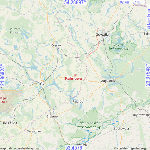
Kalinowo GPS coordinates[2]
53° 52' 28.164" North, 22° 40' 20.46" East
| Map corner | latitude | longitude |
|---|---|---|
| Upper-left | 54.28697°, | 21.96923° |
| Center: | 53.87449°, | 22.67235° |
| Lower-right: | 53.4579°, | 23.37548° |
| Map W x H: | 92.2×92.2 km | = 57.3×57.3mi |
| max Lat: | 54.83135° ⇑7% North |
| Kalinowo: | 53.87449° |
| min Lat: | ⇓93% South 49.21328° |
| min Long | Kalinowo | max Long |
| 14.20249° | 22.67235° | 24.03723° |
| W 93.6%⇐ | ⇒6.4% E |
Elevation
Elevation of Kalinowo is 148 m = 486 ft, and this is 43.4 m = 142 ft below average elevation for this country.
| Max E: |
974 m = 3196 ft | 59.5% |
| Avg. | 191.4 m = 628 ft | |
| Kalinowo | 148 m = 486 ft | |
Min E: |
-3 m = -10 ft | 40.5% |
See also: Poland elevation on elevation.city.
Geographical zone
Kalinowo is located in North temperate zone (between Tropic of Cancer and the Arctic Circle). Distance of this North polar circle is 1410.9 km =876.7 mi to North.| Distance of | km | miles | from Kalinowo |
|---|---|---|---|
| North Pole | 4016.8 | 2495.9 | to North |
| Arctic Circle | 1410.9 | 876.7 | to North |
| Tropic Cancer | 3384.4 | 2103 | to South |
| Equator | 5990.3 | 3722.2 | to South |


Nearby cities:
15 places around Kalinowo: (largest is in red/bold)
• Augustów
20.5 km =12.7 mi,  99°
99°
• Bakałarzewo
24.4 km =15.2 mi,  356°
356°
• Bargłów Kościelny
14.9 km =9.3 mi,  138°
138°
• Ełk
20.8 km =12.9 mi,  255°
255°
• Filipów
34.2 km =21.3 mi,  354°
354°
• Grajewo
29 km =18 mi,  209°
209°
• Olecko
20.7 km =12.9 mi,  328°
328°
• Prostki
25.1 km =15.6 mi,  218°
218°
• Raczki
14.6 km =9.1 mi,  30°
30°
• Rajgród
16.1 km =10 mi,  172°
172°
• Stare Juchy
33.1 km =20.6 mi,  279°
279°
• Suwałki
31.3 km =19.4 mi, 32°
• Swiętajno
27.1 km =16.8 mi,  301°
301°
• Sztabin
35.2 km =21.9 mi,  127°
127°
• Wieliczki
14.2 km =8.8 mi, 329°
Sources, notices
• [Note1] Compared only with cities in Poland existing in our database
• [Src1] Map data: © OpenStreetMap contributors (CC-BY-SA)
• [Src2] Other city data from geonames.org with taken over terms of usage.
• [Src3] Geographical zone / Annual Mean Temperature by Robert A. Rohde @ Wikipedia
