Dubienka geodata
Dubienka (Lublin) is a populated place; located in Poland in Europe/Warsaw (GMT+2) time zone. With population of 1,042 people, there are 2411 cities with bigger population in this country. Compared to other cities in Poland, 53.9% of cities are located further ↑North; 99.9% of cities are located further ←West and 52.6% of cities have lower elevation than Dubienka. Note1


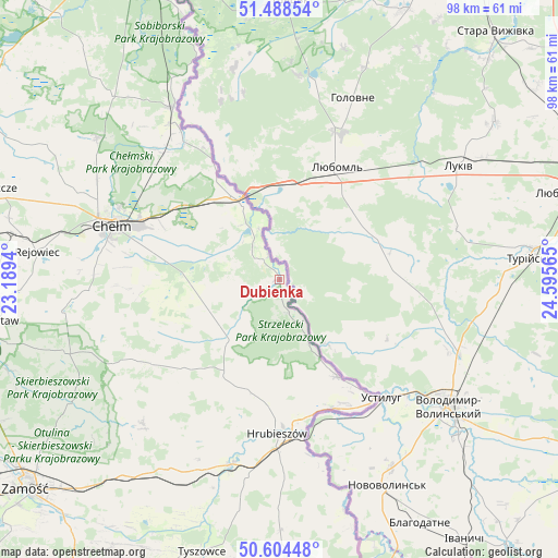
Dubienka GPS coordinates[2]
51° 2' 55.032" North, 23° 53' 33.072" East
| Map corner | latitude | longitude |
|---|---|---|
| Upper-left | 51.48854°, | 23.1894° |
| Center: | 51.04862°, | 23.89252° |
| Lower-right: | 50.60448°, | 24.59565° |
| Map W x H: | 98.3×98.3 km | = 61.1×61.1mi |
| max Lat: | 54.83135° ⇑53.9% North |
| Dubienka: | 51.04862° |
| min Lat: | ⇓46.1% South 49.21328° |
| min Long | Dubienka | max Long |
| 14.20249° | 23.89252° | 24.03723° |
| W 99.9%⇐ | ⇒0.099999999999994% E |
Elevation
Elevation of Dubienka is 179 m = 587 ft, and this is 12.4 m = 41 ft below average elevation for this country.
| Max E: |
974 m = 3196 ft | 47.4% |
| Avg. | 191.4 m = 628 ft | |
| Dubienka | 179 m = 587 ft | |
Min E: |
-3 m = -10 ft | 52.6% |
See also: Poland elevation on elevation.city.
Geographical zone
Dubienka is located in North temperate zone (between Tropic of Cancer and the Arctic Circle). Distance of this North polar circle is 1725.1 km =1071.9 mi to North.| Distance of | km | miles | from Dubienka |
|---|---|---|---|
| North Pole | 4331 | 2691.2 | to North |
| Arctic Circle | 1725.1 | 1071.9 | to North |
| Tropic Cancer | 3070.2 | 1907.7 | to South |
| Equator | 5676.1 | 3527 | to South |


Nearby cities:
15 places around Dubienka: (largest is in red/bold)
• Białopole
13.3 km =8.3 mi,  238°
238°
• Dorohusk
13.3 km =8.3 mi,  332°
332°
• Dorohusk-Osada
15.2 km =9.4 mi, 332°
• Horodło
19.9 km =12.4 mi,  149°
149°
• Hrebenne
21.3 km =13.2 mi,  156°
156°
• Hrubieszów
27.1 km =16.8 mi,  180°
180°
• Jarosławiec
20.7 km =12.9 mi,  220°
220°
• Kamień
22.1 km =13.7 mi,  283°
283°
• Pokrówka
30.4 km =18.9 mi, 279°
• Ruda-Huta
29.5 km =18.3 mi,  315°
315°
• Trzeszczany
27.5 km =17.1 mi,  203°
203°
• Uchanie
22.9 km =14.2 mi,  227°
227°
• Wojsławice
28.2 km =17.5 mi, 239°
• Świerże
21.7 km =13.5 mi, 329°
• Żmudź
15.5 km =9.6 mi,  257°
257°
Sources, notices
• [Note1] Compared only with cities in Poland existing in our database
• [Src1] Map data: © OpenStreetMap contributors (CC-BY-SA)
• [Src2] Other city data from geonames.org with taken over terms of usage.
• [Src3] Geographical zone / Annual Mean Temperature by Robert A. Rohde @ Wikipedia
