Dobre geodata
Dobre (Mazovia) is a seat of a third-order administrative division; located in Poland in Europe/Warsaw (GMT+2) time zone. With population of 1,627 people, there are 1734 cities with bigger population in this country. Compared to other cities in Poland, 73.1% of cities are located further ↓South; 81.1% of cities are located further ←West and 54.9% of cities have higher elevation than Dobre. Note1


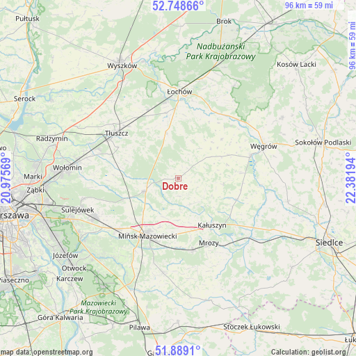
Dobre GPS coordinates[2]
52° 19' 15.492" North, 21° 40' 43.716" East
| Map corner | latitude | longitude |
|---|---|---|
| Upper-left | 52.74866°, | 20.97569° |
| Center: | 52.32097°, | 21.67881° |
| Lower-right: | 51.8891°, | 22.38194° |
| Map W x H: | 95.6×95.6 km | = 59.4×59.4mi |
| max Lat: | 54.83135° ⇑26.9% North |
| Dobre: | 52.32097° |
| min Lat: | ⇓73.1% South 49.21328° |
| min Long | Dobre | max Long |
| 14.20249° | 21.67881° | 24.03723° |
| W 81.1%⇐ | ⇒18.9% E |
Elevation
Elevation of Dobre is 159 m = 522 ft, and this is 32.4 m = 106 ft below average elevation for this country.
| Max E: |
974 m = 3196 ft | 54.9% |
| Avg. | 191.4 m = 628 ft | |
| Dobre | 159 m = 522 ft | |
Min E: |
-3 m = -10 ft | 45.1% |
See also: Poland elevation on elevation.city.
Geographical zone
Dobre is located in North temperate zone (between Tropic of Cancer and the Arctic Circle). Distance of this North polar circle is 1583.6 km =984 mi to North.| Distance of | km | miles | from Dobre |
|---|---|---|---|
| North Pole | 4189.5 | 2603.2 | to North |
| Arctic Circle | 1583.6 | 984 | to North |
| Tropic Cancer | 3211.6 | 1995.6 | to South |
| Equator | 5817.5 | 3614.8 | to South |


Nearby cities:
15 places around Dobre: (largest is in red/bold)
• Cegłów
19.7 km =12.2 mi,  168°
168°
• Grębków
16.7 km =10.4 mi,  110°
110°
• Jadów
17.8 km =11.1 mi,  349°
349°
• Jakubów
11.3 km =7 mi,  179°
179°
• Kałuszyn
15.5 km =9.6 mi,  145°
145°
• Korytnica
15.6 km =9.7 mi,  48°
48°
• Liw
20.5 km =12.7 mi,  72°
72°
• Mińsk Mazowiecki
17.3 km =10.7 mi,  204°
204°
• Mrozy
19.2 km =11.9 mi, 153°
• Poświętne
17.5 km =10.9 mi,  273°
273°
• Stanisławów
9.5 km =5.9 mi,  248°
248°
• Strachówka
12.2 km =7.6 mi, 345°
• Tłuszcz
20.5 km =12.7 mi,  306°
306°
• Wierzbno
12.3 km =7.6 mi,  95°
95°
• Wiśniew
7.7 km =4.8 mi,  156°
156°
Sources, notices
• [Note1] Compared only with cities in Poland existing in our database
• [Src1] Map data: © OpenStreetMap contributors (CC-BY-SA)
• [Src2] Other city data from geonames.org with taken over terms of usage.
• [Src3] Geographical zone / Annual Mean Temperature by Robert A. Rohde @ Wikipedia
