Ropczyce geodata
Ropczyce (Subcarpathian) is a seat of a second-order administrative division; located in Poland in Europe/Warsaw (GMT+2) time zone. With population of 15,279 people, there are 327 cities with bigger population in this country. Compared to other cities in Poland, 80% of cities are located further ↑North; 80.3% of cities are located further ←West and 63.3% of cities have lower elevation than Ropczyce. Note1
Administrative division(s):
- Level 1: Subcarpathian
- Level 2: Powiat ropczycko-sędziszowski
- Level 3: Ropczyce


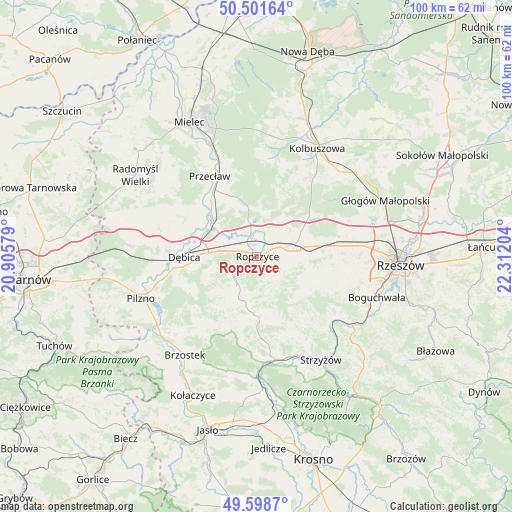
Ropczyce GPS coordinates[2]
50° 3' 8.244" North, 21° 36' 32.076" East
| Map corner | latitude | longitude |
|---|---|---|
| Upper-left | 50.50164°, | 20.90579° |
| Center: | 50.05229°, | 21.60891° |
| Lower-right: | 49.5987°, | 22.31204° |
| Map W x H: | 100.4×100.4 km | = 62.4×62.4mi |
| max Lat: | 54.83135° ⇑80% North |
| Ropczyce: | 50.05229° |
| min Lat: | ⇓20% South 49.21328° |
| min Long | Ropczyce | max Long |
| 14.20249° | 21.60891° | 24.03723° |
| W 80.3%⇐ | ⇒19.7% E |
Elevation
Elevation of Ropczyce is 210 m = 689 ft, and this is 18.6 m = 61 ft above average elevation for this country.
| Max E: |
974 m = 3196 ft | 36.7% |
| Ropczyce | 210 m 689 ft | |
| Avg. | 191.4 m = 628 ft | |
Min E: |
-3 m = -10 ft | 63.3% |
See also: Poland elevation on elevation.city.
Geographical zone
Ropczyce is located in North temperate zone (between Tropic of Cancer and the Arctic Circle). Distance of this North polar circle is 1835.9 km =1140.8 mi to North.| Distance of | km | miles | from Ropczyce |
|---|---|---|---|
| North Pole | 4441.8 | 2760 | to North |
| Arctic Circle | 1835.9 | 1140.8 | to North |
| Tropic Cancer | 2959.4 | 1838.9 | to South |
| Equator | 5565.3 | 3458.1 | to South |


Nearby cities:
15 places around Ropczyce: (largest is in red/bold)
• Brzeźnica
10.6 km =6.6 mi,  300°
300°
• Bystrzyca
11.9 km =7.4 mi,  133°
133°
• Dębica
14.1 km =8.8 mi,  269°
269°
• Iwierzyce
10.7 km =6.6 mi,  103°
103°
• Krzywa
10.5 km =6.5 mi,  59°
59°
• Niedźwiada
9.4 km =5.8 mi,  221°
221°
• Ostrów
5.2 km =3.2 mi,  347°
347°
• Przecław
18.2 km =11.3 mi,  329°
329°
• Sędziszów Małopolski
6.9 km =4.3 mi,  72°
72°
• Trzciana
16.5 km =10.3 mi,  82°
82°
• Wielopole Skrzyńskie
11.9 km =7.4 mi,  177°
177°
• Wiśniowa
12 km =7.5 mi,  120°
120°
• Zagórzyce
6.2 km =3.9 mi, 129°
• Zgłobień
18.1 km =11.2 mi, 104°
• Żyraków
15.6 km =9.7 mi,  283°
283°
Sources, notices
• [Note1] Compared only with cities in Poland existing in our database
• [Src1] Map data: © OpenStreetMap contributors (CC-BY-SA)
• [Src2] Other city data from geonames.org with taken over terms of usage.
• [Src3] Geographical zone / Annual Mean Temperature by Robert A. Rohde @ Wikipedia
