Zagórzyce geodata
Zagórzyce (Subcarpathian) is a populated place; located in Poland in Europe/Warsaw (GMT+2) time zone. With population of 3,182 people, there are 997 cities with bigger population in this country. Compared to other cities in Poland, 81.6% of cities are located further ↑North; 81% of cities are located further ←West and 71.6% of cities have lower elevation than Zagórzyce. Note1
Administrative division(s):
- Level 1: Subcarpathian
- Level 2: Powiat ropczycko-sędziszowski
- Level 3: Sędziszów Małopolski


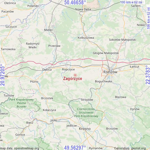
Zagórzyce GPS coordinates[2]
50° 1' 0.84" North, 21° 40' 30.612" East
| Map corner | latitude | longitude |
|---|---|---|
| Upper-left | 50.46658°, | 20.97205° |
| Center: | 50.0169°, | 21.67517° |
| Lower-right: | 49.56297°, | 22.3783° |
| Map W x H: | 100.5×100.5 km | = 62.4×62.4mi |
| max Lat: | 54.83135° ⇑81.6% North |
| Zagórzyce: | 50.0169° |
| min Lat: | ⇓18.4% South 49.21328° |
| min Long | Zagórzyce | max Long |
| 14.20249° | 21.67517° | 24.03723° |
| W 81%⇐ | ⇒19% E |
Elevation
Elevation of Zagórzyce is 234 m = 768 ft, and this is 42.6 m = 140 ft above average elevation for this country.
| Max E: |
974 m = 3196 ft | 28.4% |
| Zagórzyce | 234 m 768 ft | |
| Avg. | 191.4 m = 628 ft | |
Min E: |
-3 m = -10 ft | 71.6% |
See also: Poland elevation on elevation.city.
Geographical zone
Zagórzyce is located in North temperate zone (between Tropic of Cancer and the Arctic Circle). Distance of this North polar circle is 1839.8 km =1143.2 mi to North.| Distance of | km | miles | from Zagórzyce |
|---|---|---|---|
| North Pole | 4445.7 | 2762.4 | to North |
| Arctic Circle | 1839.8 | 1143.2 | to North |
| Tropic Cancer | 2955.4 | 1836.4 | to South |
| Equator | 5561.4 | 3455.7 | to South |


Nearby cities:
15 places around Zagórzyce: (largest is in red/bold)
• Babica
16.7 km =10.4 mi,  123°
123°
• Bystrzyca
5.8 km =3.6 mi,  138°
138°
• Czudec
14.3 km =8.9 mi, 123°
• Iwierzyce
5.8 km =3.6 mi,  75°
75°
• Krzywa
10.2 km =6.3 mi,  24°
24°
• Niechobrz
14.7 km =9.1 mi,  99°
99°
• Niedźwiada
11.4 km =7.1 mi,  254°
254°
• Ostrów
10.7 km =6.6 mi,  326°
326°
• Ropczyce
6.2 km =3.9 mi,  309°
309°
• Sędziszów Małopolski
6.3 km =3.9 mi, 16°
• Trzciana
13.2 km =8.2 mi,  62°
62°
• Wielopole Skrzyńskie
9 km =5.6 mi,  208°
208°
• Wiśniowa
6 km =3.7 mi,  110°
110°
• Wiśniowa
16.5 km =10.3 mi,  184°
184°
• Zgłobień
12.9 km =8 mi,  92°
92°
Sources, notices
• [Note1] Compared only with cities in Poland existing in our database
• [Src1] Map data: © OpenStreetMap contributors (CC-BY-SA)
• [Src2] Other city data from geonames.org with taken over terms of usage.
• [Src3] Geographical zone / Annual Mean Temperature by Robert A. Rohde @ Wikipedia
