Albigowa geodata
Albigowa (Subcarpathian) is a populated place; located in Poland in Europe/Warsaw (GMT+2) time zone. With population of 2,923 people, there are 1083 cities with bigger population in this country. Compared to other cities in Poland, 81.7% of cities are located further ↑North; 87.6% of cities are located further ←West and 70.9% of cities have lower elevation than Albigowa. Note1


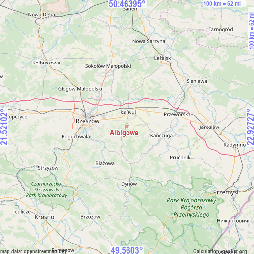
Albigowa GPS coordinates[2]
50° 0' 51.3" North, 22° 13' 26.904" East
| Map corner | latitude | longitude |
|---|---|---|
| Upper-left | 50.46395°, | 21.52102° |
| Center: | 50.01425°, | 22.22414° |
| Lower-right: | 49.5603°, | 22.92727° |
| Map W x H: | 100.5×100.5 km | = 62.4×62.4mi |
| max Lat: | 54.83135° ⇑81.7% North |
| Albigowa: | 50.01425° |
| min Lat: | ⇓18.3% South 49.21328° |
| min Long | Albigowa | max Long |
| 14.20249° | 22.22414° | 24.03723° |
| W 87.6%⇐ | ⇒12.4% E |
Elevation
Elevation of Albigowa is 232 m = 761 ft, and this is 40.6 m = 133 ft above average elevation for this country.
| Max E: |
974 m = 3196 ft | 29.1% |
| Albigowa | 232 m 761 ft | |
| Avg. | 191.4 m = 628 ft | |
Min E: |
-3 m = -10 ft | 70.9% |
See also: Poland elevation on elevation.city.
Geographical zone
Albigowa is located in North temperate zone (between Tropic of Cancer and the Arctic Circle). Distance of this North polar circle is 1840.1 km =1143.4 mi to North.| Distance of | km | miles | from Albigowa |
|---|---|---|---|
| North Pole | 4446 | 2762.6 | to North |
| Arctic Circle | 1840.1 | 1143.4 | to North |
| Tropic Cancer | 2955.1 | 1836.2 | to South |
| Equator | 5561.1 | 3455.5 | to South |


Nearby cities:
15 places around Albigowa: (largest is in red/bold)
• Chmielnik
7.2 km =4.5 mi,  231°
231°
• Czarna
11 km =6.8 mi,  344°
344°
• Gać
9.7 km =6 mi,  81°
81°
• Głuchów
8.2 km =5.1 mi,  24°
24°
• Handzlówka
2.1 km =1.3 mi,  181°
181°
• Husów
5.9 km =3.7 mi,  130°
130°
• Kosina
9.9 km =6.2 mi,  49°
49°
• Kraczkowa
4.8 km =3 mi,  303°
303°
• Krasne
10.9 km =6.8 mi, 295°
• Krzemienica
6.2 km =3.9 mi,  329°
329°
• Markowa
7.8 km =4.8 mi, 80°
• Sietesz
9.3 km =5.8 mi,  109°
109°
• Sonina
6 km =3.7 mi,  29°
29°
• Wysoka
4.2 km =2.6 mi,  37°
37°
• Łańcut
6.1 km =3.8 mi,  3°
3°
Sources, notices
• [Note1] Compared only with cities in Poland existing in our database
• [Src1] Map data: © OpenStreetMap contributors (CC-BY-SA)
• [Src2] Other city data from geonames.org with taken over terms of usage.
• [Src3] Geographical zone / Annual Mean Temperature by Robert A. Rohde @ Wikipedia
