Hyżne geodata
Hyżne (Subcarpathian) is a seat of a third-order administrative division; located in Poland in Europe/Warsaw (GMT+2) time zone. With population of 3,900 people, there are 834 cities with bigger population in this country. Compared to other cities in Poland, 86.8% of cities are located further ↑North; 87.2% of cities are located further ←West and 77.9% of cities have lower elevation than Hyżne. Note1


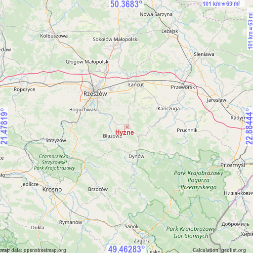
Hyżne GPS coordinates[2]
49° 55' 3.684" North, 22° 10' 52.716" East
| Map corner | latitude | longitude |
|---|---|---|
| Upper-left | 50.3683°, | 21.47819° |
| Center: | 49.91769°, | 22.18131° |
| Lower-right: | 49.46283°, | 22.88444° |
| Map W x H: | 100.7×100.7 km | = 62.6×62.6mi |
| max Lat: | 54.83135° ⇑86.8% North |
| Hyżne: | 49.91769° |
| min Lat: | ⇓13.2% South 49.21328° |
| min Long | Hyżne | max Long |
| 14.20249° | 22.18131° | 24.03723° |
| W 87.2%⇐ | ⇒12.8% E |
Elevation
Elevation of Hyżne is 257 m = 843 ft, and this is 65.6 m = 215 ft above average elevation for this country.
| Max E: |
974 m = 3196 ft | 22.1% |
| Hyżne | 257 m 843 ft | |
| Avg. | 191.4 m = 628 ft | |
Min E: |
-3 m = -10 ft | 77.9% |
See also: Poland elevation on elevation.city.
Geographical zone
Hyżne is located in North temperate zone (between Tropic of Cancer and the Arctic Circle). Distance of this North polar circle is 1850.8 km =1150 mi to North.| Distance of | km | miles | from Hyżne |
|---|---|---|---|
| North Pole | 4456.7 | 2769.3 | to North |
| Arctic Circle | 1850.8 | 1150 | to North |
| Tropic Cancer | 2944.4 | 1829.6 | to South |
| Equator | 5550.3 | 3448.8 | to South |


Nearby cities:
15 places around Hyżne: (largest is in red/bold)
• Albigowa
11.2 km =7 mi,  15°
15°
• Białka
11.7 km =7.3 mi,  243°
243°
• Błażowa
6.8 km =4.2 mi, 238°
• Chmielnik
6.8 km =4.2 mi,  337°
337°
• Drohobyczka
14.2 km =8.8 mi,  118°
118°
• Dynów
12 km =7.5 mi,  161°
161°
• Hadle Szklarskie
8.5 km =5.3 mi,  94°
94°
• Handzlówka
9.1 km =5.7 mi, 19°
• Husów
10.2 km =6.3 mi,  47°
47°
• Jawornik Polski
8.2 km =5.1 mi,  111°
111°
• Kraczkowa
13.4 km =8.3 mi,  355°
355°
• Lecka
12.8 km =8 mi,  250°
250°
• Manasterz
11.9 km =7.4 mi,  80°
80°
• Sietesz
14.1 km =8.8 mi,  57°
57°
• Tyczyn
11.7 km =7.3 mi,  295°
295°
Sources, notices
• [Note1] Compared only with cities in Poland existing in our database
• [Src1] Map data: © OpenStreetMap contributors (CC-BY-SA)
• [Src2] Other city data from geonames.org with taken over terms of usage.
• [Src3] Geographical zone / Annual Mean Temperature by Robert A. Rohde @ Wikipedia
