Sonina geodata
Sonina (Subcarpathian) is a populated place; located in Poland in Europe/Warsaw (GMT+2) time zone. With population of 2,836 people, there are 1108 cities with bigger population in this country. Compared to other cities in Poland, 79.6% of cities are located further ↑North; 88.3% of cities are located further ←West and 61.5% of cities have lower elevation than Sonina. Note1


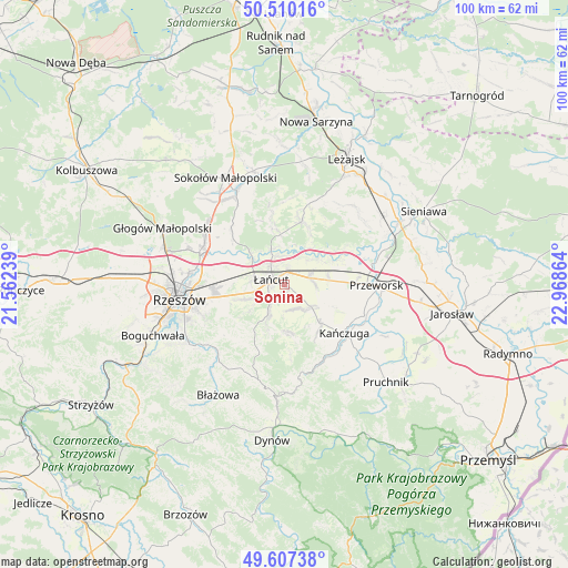
Sonina GPS coordinates[2]
50° 3' 39.204" North, 22° 15' 55.836" East
| Map corner | latitude | longitude |
|---|---|---|
| Upper-left | 50.51016°, | 21.56239° |
| Center: | 50.06089°, | 22.26551° |
| Lower-right: | 49.60738°, | 22.96864° |
| Map W x H: | 100.4×100.4 km | = 62.4×62.4mi |
| max Lat: | 54.83135° ⇑79.6% North |
| Sonina: | 50.06089° |
| min Lat: | ⇓20.4% South 49.21328° |
| min Long | Sonina | max Long |
| 14.20249° | 22.26551° | 24.03723° |
| W 88.3%⇐ | ⇒11.7% E |
Elevation
Elevation of Sonina is 204 m = 669 ft, and this is 12.6 m = 41 ft above average elevation for this country.
| Max E: |
974 m = 3196 ft | 38.5% |
| Sonina | 204 m 669 ft | |
| Avg. | 191.4 m = 628 ft | |
Min E: |
-3 m = -10 ft | 61.5% |
See also: Poland elevation on elevation.city.
Geographical zone
Sonina is located in North temperate zone (between Tropic of Cancer and the Arctic Circle). Distance of this North polar circle is 1834.9 km =1140.2 mi to North.| Distance of | km | miles | from Sonina |
|---|---|---|---|
| North Pole | 4440.8 | 2759.4 | to North |
| Arctic Circle | 1834.9 | 1140.2 | to North |
| Tropic Cancer | 2960.3 | 1839.4 | to South |
| Equator | 5566.2 | 3458.7 | to South |


Nearby cities:
15 places around Sonina: (largest is in red/bold)
• Albigowa
6 km =3.7 mi,  209°
209°
• Białobrzegi
6 km =3.7 mi,  39°
39°
• Czarna
8.1 km =5 mi,  312°
312°
• Gać
7.7 km =4.8 mi,  119°
119°
• Głuchów
2.4 km =1.5 mi,  10°
10°
• Handzlówka
7.9 km =4.9 mi,  202°
202°
• Husów
9.1 km =5.7 mi,  170°
170°
• Kosina
4.7 km =2.9 mi,  74°
74°
• Kraczkowa
7.4 km =4.6 mi,  249°
249°
• Krzemienica
6.1 km =3.8 mi,  271°
271°
• Markowa
6.1 km =3.8 mi,  129°
129°
• Rogóźno
7.9 km =4.9 mi,  79°
79°
• Sietesz
10.1 km =6.3 mi,  145°
145°
• Wysoka
1.8 km =1.1 mi,  192°
192°
• Łańcut
2.7 km =1.7 mi,  288°
288°
Sources, notices
• [Note1] Compared only with cities in Poland existing in our database
• [Src1] Map data: © OpenStreetMap contributors (CC-BY-SA)
• [Src2] Other city data from geonames.org with taken over terms of usage.
• [Src3] Geographical zone / Annual Mean Temperature by Robert A. Rohde @ Wikipedia
