Chmielnik geodata
Chmielnik (Subcarpathian) is a seat of a third-order administrative division; located in Poland in Europe/Warsaw (GMT+2) time zone. With population of 3,466 people, there are 921 cities with bigger population in this country. Compared to other cities in Poland, 84.2% of cities are located further ↑North; 86.8% of cities are located further ←West and 73.4% of cities have lower elevation than Chmielnik. Note1


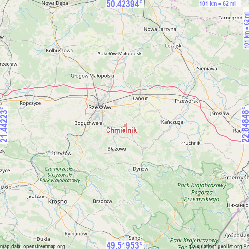
Chmielnik GPS coordinates[2]
49° 58' 25.896" North, 22° 8' 43.26" East
| Map corner | latitude | longitude |
|---|---|---|
| Upper-left | 50.42394°, | 21.44223° |
| Center: | 49.97386°, | 22.14535° |
| Lower-right: | 49.51953°, | 22.84848° |
| Map W x H: | 100.6×100.6 km | = 62.5×62.5mi |
| max Lat: | 54.83135° ⇑84.2% North |
| Chmielnik: | 49.97386° |
| min Lat: | ⇓15.8% South 49.21328° |
| min Long | Chmielnik | max Long |
| 14.20249° | 22.14535° | 24.03723° |
| W 86.8%⇐ | ⇒13.2% E |
Elevation
Elevation of Chmielnik is 241 m = 791 ft, and this is 49.6 m = 163 ft above average elevation for this country.
| Max E: |
974 m = 3196 ft | 26.6% |
| Chmielnik | 241 m 791 ft | |
| Avg. | 191.4 m = 628 ft | |
Min E: |
-3 m = -10 ft | 73.4% |
See also: Poland elevation on elevation.city.
Geographical zone
Chmielnik is located in North temperate zone (between Tropic of Cancer and the Arctic Circle). Distance of this North polar circle is 1844.6 km =1146.2 mi to North.| Distance of | km | miles | from Chmielnik |
|---|---|---|---|
| North Pole | 4450.5 | 2765.4 | to North |
| Arctic Circle | 1844.6 | 1146.2 | to North |
| Tropic Cancer | 2950.7 | 1833.5 | to South |
| Equator | 5556.6 | 3452.7 | to South |


Nearby cities:
15 places around Chmielnik: (largest is in red/bold)
• Albigowa
7.2 km =4.5 mi,  51°
51°
• Błażowa
10.4 km =6.5 mi,  198°
198°
• Hadle Szklarskie
13 km =8.1 mi,  122°
122°
• Handzlówka
6 km =3.7 mi,  66°
66°
• Husów
10.1 km =6.3 mi,  86°
86°
• Hyżne
6.8 km =4.2 mi,  157°
157°
• Jawornik Polski
13.8 km =8.6 mi,  131°
131°
• Kraczkowa
7.3 km =4.5 mi,  12°
12°
• Krasne
10.1 km =6.3 mi,  335°
335°
• Krzemienica
10.1 km =6.3 mi, 14°
• Rzeszów
12.9 km =8 mi,  305°
305°
• Sonina
12.9 km =8 mi,  41°
41°
• Tyczyn
8 km =5 mi,  262°
262°
• Wysoka
11.4 km =7.1 mi, 46°
• Łańcut
12.1 km =7.5 mi,  29°
29°
Sources, notices
• [Note1] Compared only with cities in Poland existing in our database
• [Src1] Map data: © OpenStreetMap contributors (CC-BY-SA)
• [Src2] Other city data from geonames.org with taken over terms of usage.
• [Src3] Geographical zone / Annual Mean Temperature by Robert A. Rohde @ Wikipedia
