Wola Jachowa geodata
Wola Jachowa (Świętokrzyskie) is a populated place; located in Poland in Europe/Warsaw (GMT+2) time zone. With population of 1,300 people, there are 2055 cities with bigger population in this country. Compared to other cities in Poland, 59.3% of cities are located further ↑North; 70.1% of cities are located further ←West and 82.1% of cities have lower elevation than Wola Jachowa. Note1


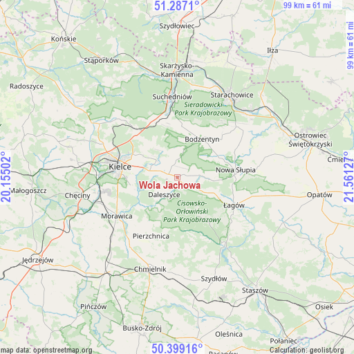
Wola Jachowa GPS coordinates[2]
50° 50' 42.864" North, 20° 51' 29.304" East
| Map corner | latitude | longitude |
|---|---|---|
| Upper-left | 51.2871°, | 20.15502° |
| Center: | 50.84524°, | 20.85814° |
| Lower-right: | 50.39916°, | 21.56127° |
| Map W x H: | 98.7×98.7 km | = 61.3×61.3mi |
| max Lat: | 54.83135° ⇑59.3% North |
| Wola Jachowa: | 50.84524° |
| min Lat: | ⇓40.7% South 49.21328° |
| min Long | Wola Jachowa | max Long |
| 14.20249° | 20.85814° | 24.03723° |
| W 70.1%⇐ | ⇒29.9% E |
Elevation
Elevation of Wola Jachowa is 276 m = 906 ft, and this is 84.6 m = 278 ft above average elevation for this country.
| Max E: |
974 m = 3196 ft | 17.9% |
| Wola Jachowa | 276 m 906 ft | |
| Avg. | 191.4 m = 628 ft | |
Min E: |
-3 m = -10 ft | 82.1% |
See also: Poland elevation on elevation.city.
Geographical zone
Wola Jachowa is located in North temperate zone (between Tropic of Cancer and the Arctic Circle). Distance of this North polar circle is 1747.7 km =1086 mi to North.| Distance of | km | miles | from Wola Jachowa |
|---|---|---|---|
| North Pole | 4353.6 | 2705.2 | to North |
| Arctic Circle | 1747.7 | 1086 | to North |
| Tropic Cancer | 3047.5 | 1893.6 | to South |
| Equator | 5653.5 | 3512.9 | to South |


Nearby cities:
15 places around Wola Jachowa: (largest is in red/bold)
• Bieliny
5.9 km =3.7 mi,  85°
85°
• Bodzentyn
12.7 km =7.9 mi,  33°
33°
• Daleszyce
5.9 km =3.7 mi,  216°
216°
• Domaszowice
12.7 km =7.9 mi,  284°
284°
• Górno
2.3 km =1.4 mi, 276°
• Gózd
16.7 km =10.4 mi,  337°
337°
• Kielce
16.4 km =10.2 mi, 279°
• Masłów
11.3 km =7 mi,  303°
303°
• Nowa Słupia
16.4 km =10.2 mi,  82°
82°
• Pierzchnica
18 km =11.2 mi,  203°
203°
• Sosnówka
17.3 km =10.7 mi,  68°
68°
• Stara Słupia
18.7 km =11.6 mi, 79°
• Wiśniowa
16.8 km =10.4 mi,  104°
104°
• Łagów
17.7 km =11 mi,  116°
116°
• Łączna
18 km =11.2 mi,  346°
346°
Sources, notices
• [Note1] Compared only with cities in Poland existing in our database
• [Src1] Map data: © OpenStreetMap contributors (CC-BY-SA)
• [Src2] Other city data from geonames.org with taken over terms of usage.
• [Src3] Geographical zone / Annual Mean Temperature by Robert A. Rohde @ Wikipedia
