Mikołajki geodata
Mikołajki (Warmia-Masuria) is a seat of a third-order administrative division; located in Poland in Europe/Warsaw (GMT+2) time zone. With population of 3,851 people, there are 847 cities with bigger population in this country. Compared to other cities in Poland, 92.3% of cities are located further ↓South; 79.8% of cities are located further ←West and 71.1% of cities have higher elevation than Mikołajki. Note1


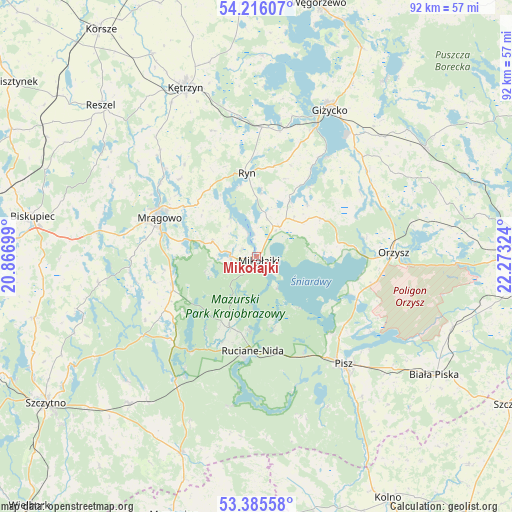
Mikołajki GPS coordinates[2]
53° 48' 10.368" North, 21° 34' 12.396" East
| Map corner | latitude | longitude |
|---|---|---|
| Upper-left | 54.21607°, | 20.86699° |
| Center: | 53.80288°, | 21.57011° |
| Lower-right: | 53.38558°, | 22.27324° |
| Map W x H: | 92.3×92.3 km | = 57.4×57.4mi |
| max Lat: | 54.83135° ⇑7.7% North |
| Mikołajki: | 53.80288° |
| min Lat: | ⇓92.3% South 49.21328° |
| min Long | Mikołajki | max Long |
| 14.20249° | 21.57011° | 24.03723° |
| W 79.8%⇐ | ⇒20.2% E |
Elevation
Elevation of Mikołajki is 119 m = 390 ft, and this is 72.4 m = 238 ft below average elevation for this country.
| Max E: |
974 m = 3196 ft | 71.1% |
| Avg. | 191.4 m = 628 ft | |
| Mikołajki | 119 m = 390 ft | |
Min E: |
-3 m = -10 ft | 28.9% |
See also: Poland elevation on elevation.city.
Geographical zone
Mikołajki is located in North temperate zone (between Tropic of Cancer and the Arctic Circle). Distance of this North polar circle is 1418.9 km =881.7 mi to North.| Distance of | km | miles | from Mikołajki |
|---|---|---|---|
| North Pole | 4024.7 | 2500.8 | to North |
| Arctic Circle | 1418.9 | 881.7 | to North |
| Tropic Cancer | 3376.4 | 2098 | to South |
| Equator | 5982.3 | 3717.2 | to South |


Nearby cities:
15 places around Mikołajki: (largest is in red/bold)
• Baranowo
8.5 km =5.3 mi,  287°
287°
• Gierłoż
31.3 km =19.4 mi,  351°
351°
• Giżycko
29.1 km =18.1 mi,  25°
25°
• Kętrzyn
33 km =20.5 mi,  337°
337°
• Miłki
25.8 km =16 mi,  52°
52°
• Mrągowo
18.7 km =11.6 mi, 291°
• Orzysz
24.8 km =15.4 mi,  88°
88°
• Piecki
16 km =9.9 mi,  251°
251°
• Pisz
25.2 km =15.7 mi,  140°
140°
• Rozogi
37.9 km =23.5 mi,  201°
201°
• Ruciane-Nida
18 km =11.2 mi,  186°
186°
• Ryn
15.1 km =9.4 mi, 354°
• Sorkwity
28.6 km =17.8 mi,  279°
279°
• Wydminy
36.2 km =22.5 mi,  56°
56°
• Świętajno
35.1 km =21.8 mi,  221°
221°
Sources, notices
• [Note1] Compared only with cities in Poland existing in our database
• [Src1] Map data: © OpenStreetMap contributors (CC-BY-SA)
• [Src2] Other city data from geonames.org with taken over terms of usage.
• [Src3] Geographical zone / Annual Mean Temperature by Robert A. Rohde @ Wikipedia
