Kolno geodata
Kolno (Warmia-Masuria) is a populated place; located in Poland in Europe/Warsaw (GMT+2) time zone. With population of 590 people, there are 3306 cities with bigger population in this country. Compared to other cities in Poland, 94.1% of cities are located further ↓South; 72.6% of cities are located further ←West and 69.8% of cities have higher elevation than Kolno. Note1


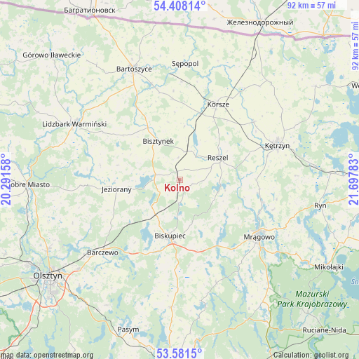
Kolno GPS coordinates[2]
53° 59' 48.732" North, 20° 59' 40.92" East
| Map corner | latitude | longitude |
|---|---|---|
| Upper-left | 54.40814°, | 20.29158° |
| Center: | 53.99687°, | 20.9947° |
| Lower-right: | 53.5815°, | 21.69783° |
| Map W x H: | 91.9×91.9 km | = 57.1×57.1mi |
| max Lat: | 54.83135° ⇑5.9% North |
| Kolno: | 53.99687° |
| min Lat: | ⇓94.1% South 49.21328° |
| min Long | Kolno | max Long |
| 14.20249° | 20.9947° | 24.03723° |
| W 72.6%⇐ | ⇒27.4% E |
Elevation
Elevation of Kolno is 121 m = 397 ft, and this is 70.4 m = 231 ft below average elevation for this country.
| Max E: |
974 m = 3196 ft | 69.8% |
| Avg. | 191.4 m = 628 ft | |
| Kolno | 121 m = 397 ft | |
Min E: |
-3 m = -10 ft | 30.2% |
See also: Poland elevation on elevation.city.
Geographical zone
Kolno is located in North temperate zone (between Tropic of Cancer and the Arctic Circle). Distance of this North polar circle is 1397.3 km =868.2 mi to North.| Distance of | km | miles | from Kolno |
|---|---|---|---|
| North Pole | 4003.2 | 2487.5 | to North |
| Arctic Circle | 1397.3 | 868.2 | to North |
| Tropic Cancer | 3398 | 2111.4 | to South |
| Equator | 6003.9 | 3730.6 | to South |


Nearby cities:
15 places around Kolno: (largest is in red/bold)
• Barczewo
27.2 km =16.9 mi,  227°
227°
• Bartoszyce
31 km =19.3 mi,  336°
336°
• Biskupiec
14.9 km =9.3 mi,  189°
189°
• Bisztynek
11.6 km =7.2 mi,  328°
328°
• Czerwonka
11 km =6.8 mi,  215°
215°
• Dźwierzuty
32.5 km =20.2 mi,  183°
183°
• Gierłoż
34 km =21.1 mi,  73°
73°
• Jeziorany
16.4 km =10.2 mi,  261°
261°
• Korsze
21.4 km =13.3 mi,  26°
26°
• Kętrzyn
26.4 km =16.4 mi, 70°
• Lidzbark Warmiński
30.7 km =19.1 mi,  297°
297°
• Mrągowo
25.1 km =15.6 mi,  125°
125°
• Reszel
11.5 km =7.1 mi,  58°
58°
• Sorkwity
19.3 km =12 mi,  150°
150°
• Sępopol
30.3 km =18.8 mi,  2°
2°
Sources, notices
• [Note1] Compared only with cities in Poland existing in our database
• [Src1] Map data: © OpenStreetMap contributors (CC-BY-SA)
• [Src2] Other city data from geonames.org with taken over terms of usage.
• [Src3] Geographical zone / Annual Mean Temperature by Robert A. Rohde @ Wikipedia
