Barciany geodata
Barciany (Warmia-Masuria) is a populated place; located in Poland in Europe/Warsaw (GMT+2) time zone. With population of 1,100 people, there are 2307 cities with bigger population in this country. Compared to other cities in Poland, 96.6% of cities are located further ↓South; 77.6% of cities are located further ←West and 92.7% of cities have higher elevation than Barciany. Note1


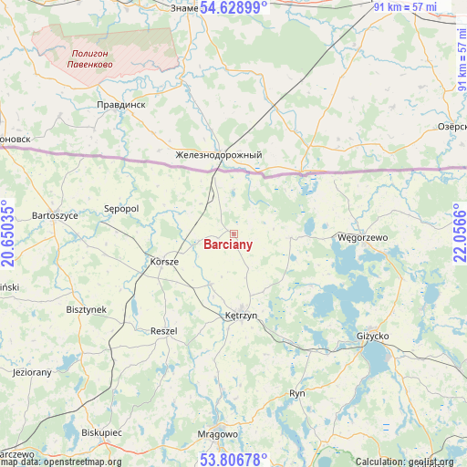
Barciany GPS coordinates[2]
54° 13' 11.748" North, 21° 21' 12.492" East
| Map corner | latitude | longitude |
|---|---|---|
| Upper-left | 54.62899°, | 20.65035° |
| Center: | 54.21993°, | 21.35347° |
| Lower-right: | 53.80678°, | 22.0566° |
| Map W x H: | 91.4×91.4 km | = 56.8×56.8mi |
| max Lat: | 54.83135° ⇑3.4% North |
| Barciany: | 54.21993° |
| min Lat: | ⇓96.6% South 49.21328° |
| min Long | Barciany | max Long |
| 14.20249° | 21.35347° | 24.03723° |
| W 77.6%⇐ | ⇒22.4% E |
Elevation
Elevation of Barciany is 61 m = 200 ft, and this is 130.4 m = 428 ft below average elevation for this country.
| Max E: |
974 m = 3196 ft | 92.7% |
| Avg. | 191.4 m = 628 ft | |
| Barciany | 61 m = 200 ft | |
Min E: |
-3 m = -10 ft | 7.3% |
See also: Poland elevation on elevation.city.
Geographical zone
Barciany is located in North temperate zone (between Tropic of Cancer and the Arctic Circle). Distance of this North polar circle is 1372.5 km =852.8 mi to North.| Distance of | km | miles | from Barciany |
|---|---|---|---|
| North Pole | 3978.4 | 2472.1 | to North |
| Arctic Circle | 1372.5 | 852.8 | to North |
| Tropic Cancer | 3422.8 | 2126.8 | to South |
| Equator | 6028.7 | 3746.1 | to South |


Nearby cities:
15 places around Barciany: (largest is in red/bold)
• Bartoszyce
35.6 km =22.1 mi,  276°
276°
• Bisztynek
32.9 km =20.4 mi,  243°
243°
• Gierłoż
18 km =11.2 mi,  149°
149°
• Giżycko
33.5 km =20.8 mi,  127°
127°
• Kolno
34.1 km =21.2 mi,  223°
223°
• Korsze
15 km =9.3 mi,  248°
248°
• Kruklanki
39.8 km =24.7 mi,  111°
111°
• Kętrzyn
16 km =9.9 mi,  174°
174°
• Mrągowo
39.7 km =24.7 mi,  184°
184°
• Pozezdrze
34.1 km =21.2 mi,  104°
104°
• Reszel
23.2 km =14.4 mi, 215°
• Ryn
33.8 km =21 mi,  158°
158°
• Srokowo
11 km =6.8 mi,  93°
93°
• Sępopol
22.7 km =14.1 mi, 283°
• Węgorzewo
25 km =15.5 mi, 91°
Sources, notices
• [Note1] Compared only with cities in Poland existing in our database
• [Src1] Map data: © OpenStreetMap contributors (CC-BY-SA)
• [Src2] Other city data from geonames.org with taken over terms of usage.
• [Src3] Geographical zone / Annual Mean Temperature by Robert A. Rohde @ Wikipedia
