Reszel geodata
Reszel (Warmia-Masuria) is a populated place; located in Poland in Europe/Warsaw (GMT+2) time zone. With population of 5,226 people, there are 665 cities with bigger population in this country. Compared to other cities in Poland, 94.7% of cities are located further ↓South; 75.1% of cities are located further ←West and 75.4% of cities have higher elevation than Reszel. Note1


Reszel GPS coordinates[2]
54° 3' 1.512" North, 21° 8' 45.06" East
| Map corner | latitude | longitude |
|---|---|---|
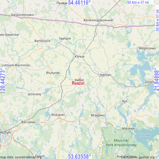
| Upper-left | 54.46116°, | 20.44273° |
| Center: | 54.05042°, | 21.14585° |
| Lower-right: | 53.63558°, | 21.84898° |
| Map W x H: | 91.8×91.8 km | = 57×57mi |
| max Lat: | 54.83135° ⇑5.3% North |
| Reszel: | 54.05042° |
| min Lat: | ⇓94.7% South 49.21328° |
| min Long | Reszel | max Long |
| 14.20249° | 21.14585° | 24.03723° |
| W 75.1%⇐ | ⇒24.9% E |
Elevation
Elevation of Reszel is 110 m = 361 ft, and this is 81.4 m = 267 ft below average elevation for this country.
| Max E: |
974 m = 3196 ft | 75.4% |
| Avg. | 191.4 m = 628 ft | |
| Reszel | 110 m = 361 ft | |
Min E: |
-3 m = -10 ft | 24.6% |
See also: Poland elevation on elevation.city.
Geographical zone
Reszel is located in North temperate zone (between Tropic of Cancer and the Arctic Circle). Distance of this North polar circle is 1391.3 km =864.5 mi to North.| Distance of | km | miles | from Reszel |
|---|---|---|---|
| North Pole | 3997.2 | 2483.7 | to North |
| Arctic Circle | 1391.3 | 864.5 | to North |
| Tropic Cancer | 3403.9 | 2115.1 | to South |
| Equator | 6009.8 | 3734.3 | to South |


Nearby cities:
15 places around Reszel: (largest is in red/bold)
• Barciany
23.2 km =14.4 mi,  35°
35°
• Bartoszyce
31.5 km =19.6 mi,  315°
315°
• Biskupiec
24.1 km =15 mi,  210°
210°
• Bisztynek
16.4 km =10.2 mi,  284°
284°
• Czerwonka
22.1 km =13.7 mi,  227°
227°
• Gierłoż
23.1 km =14.4 mi,  81°
81°
• Jeziorany
27.4 km =17 mi,  252°
252°
• Kolno
11.5 km =7.1 mi,  238°
238°
• Korsze
13.3 km =8.3 mi,  358°
358°
• Kętrzyn
15.3 km =9.5 mi, 78°
• Mrągowo
23.2 km =14.4 mi,  153°
153°
• Ryn
29 km =18 mi,  115°
115°
• Sorkwity
22.8 km =14.2 mi,  180°
180°
• Srokowo
30.6 km =19 mi,  53°
53°
• Sępopol
25.8 km =16 mi,  340°
340°
Sources, notices
• [Note1] Compared only with cities in Poland existing in our database
• [Src1] Map data: © OpenStreetMap contributors (CC-BY-SA)
• [Src2] Other city data from geonames.org with taken over terms of usage.
• [Src3] Geographical zone / Annual Mean Temperature by Robert A. Rohde @ Wikipedia
