Kętrzyn geodata
Kętrzyn (Warmia-Masuria) is a populated place; located in Poland in Europe/Warsaw (GMT+2) time zone. With population of 28,171 people, there are 175 cities with bigger population in this country. Compared to other cities in Poland, 95% of cities are located further ↓South; 77.7% of cities are located further ←West and 78.4% of cities have higher elevation than Kętrzyn. Note1


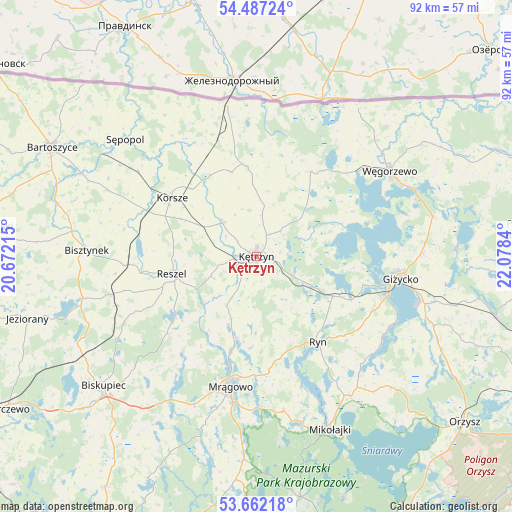
Kętrzyn GPS coordinates[2]
54° 4' 36.336" North, 21° 22' 30.972" East
| Map corner | latitude | longitude |
|---|---|---|
| Upper-left | 54.48724°, | 20.67215° |
| Center: | 54.07676°, | 21.37527° |
| Lower-right: | 53.66218°, | 22.0784° |
| Map W x H: | 91.7×91.7 km | = 57×57mi |
| max Lat: | 54.83135° ⇑5% North |
| Kętrzyn: | 54.07676° |
| min Lat: | ⇓95% South 49.21328° |
| min Long | Kętrzyn | max Long |
| 14.20249° | 21.37527° | 24.03723° |
| W 77.7%⇐ | ⇒22.3% E |
Elevation
Elevation of Kętrzyn is 103 m = 338 ft, and this is 88.4 m = 290 ft below average elevation for this country.
| Max E: |
974 m = 3196 ft | 78.4% |
| Avg. | 191.4 m = 628 ft | |
| Kętrzyn | 103 m = 338 ft | |
Min E: |
-3 m = -10 ft | 21.6% |
See also: Poland elevation on elevation.city.
Geographical zone
Kętrzyn is located in North temperate zone (between Tropic of Cancer and the Arctic Circle). Distance of this North polar circle is 1388.4 km =862.7 mi to North.| Distance of | km | miles | from Kętrzyn |
|---|---|---|---|
| North Pole | 3994.3 | 2481.9 | to North |
| Arctic Circle | 1388.4 | 862.7 | to North |
| Tropic Cancer | 3406.9 | 2116.9 | to South |
| Equator | 6012.8 | 3736.2 | to South |


Nearby cities:
15 places around Kętrzyn: (largest is in red/bold)
• Baranowo
28.2 km =17.5 mi,  170°
170°
• Barciany
16 km =9.9 mi,  354°
354°
• Bisztynek
30.9 km =19.2 mi,  271°
271°
• Gierłoż
7.9 km =4.9 mi,  86°
86°
• Giżycko
25.8 km =16 mi,  99°
99°
• Kolno
26.4 km =16.4 mi,  250°
250°
• Korsze
18.6 km =11.6 mi,  303°
303°
• Mrągowo
24.1 km =15 mi,  191°
191°
• Pozezdrze
32.4 km =20.1 mi,  77°
77°
• Reszel
15.3 km =9.5 mi,  258°
258°
• Ryn
19.1 km =11.9 mi,  144°
144°
• Sorkwity
29.9 km =18.6 mi,  210°
210°
• Srokowo
18 km =11.2 mi,  32°
32°
• Sępopol
31.8 km =19.8 mi,  312°
312°
• Węgorzewo
28.2 km =17.5 mi,  56°
56°
Sources, notices
• [Note1] Compared only with cities in Poland existing in our database
• [Src1] Map data: © OpenStreetMap contributors (CC-BY-SA)
• [Src2] Other city data from geonames.org with taken over terms of usage.
• [Src3] Geographical zone / Annual Mean Temperature by Robert A. Rohde @ Wikipedia
