Potworów geodata
Potworów (Mazovia) is a seat of a third-order administrative division; located in Poland in Europe/Warsaw (GMT+2) time zone. With population of 990 people, there are 2509 cities with bigger population in this country. Compared to other cities in Poland, 56.5% of cities are located further ↓South; 68% of cities are located further ←West and 51.2% of cities have lower elevation than Potworów. Note1


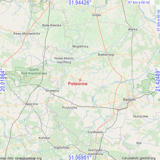
Potworów GPS coordinates[2]
51° 30' 31.464" North, 20° 43' 18.336" East
| Map corner | latitude | longitude |
|---|---|---|
| Upper-left | 51.94426°, | 20.01864° |
| Center: | 51.50874°, | 20.72176° |
| Lower-right: | 51.06901°, | 21.42489° |
| Map W x H: | 97.3×97.3 km | = 60.5×60.5mi |
| max Lat: | 54.83135° ⇑43.5% North |
| Potworów: | 51.50874° |
| min Lat: | ⇓56.5% South 49.21328° |
| min Long | Potworów | max Long |
| 14.20249° | 20.72176° | 24.03723° |
| W 68%⇐ | ⇒32% E |
Elevation
Elevation of Potworów is 175 m = 574 ft, and this is 16.4 m = 54 ft below average elevation for this country.
| Max E: |
974 m = 3196 ft | 48.8% |
| Avg. | 191.4 m = 628 ft | |
| Potworów | 175 m = 574 ft | |
Min E: |
-3 m = -10 ft | 51.2% |
See also: Poland elevation on elevation.city.
Geographical zone
Potworów is located in North temperate zone (between Tropic of Cancer and the Arctic Circle). Distance of this North polar circle is 1673.9 km =1040.1 mi to North.| Distance of | km | miles | from Potworów |
|---|---|---|---|
| North Pole | 4279.8 | 2659.3 | to North |
| Arctic Circle | 1673.9 | 1040.1 | to North |
| Tropic Cancer | 3121.3 | 1939.5 | to South |
| Equator | 5727.2 | 3558.7 | to South |


Nearby cities:
15 places around Potworów: (largest is in red/bold)
• Drzewica
18.1 km =11.2 mi,  249°
249°
• Gielniów
20.5 km =12.7 mi,  234°
234°
• Klwów
6.6 km =4.1 mi,  295°
295°
• Mogielnica
20.6 km =12.8 mi,  0°
0°
• Nowe Miasto nad Pilicą
15.8 km =9.8 mi,  320°
320°
• Odrzywół
11.6 km =7.2 mi,  275°
275°
• Przybyszew
19.4 km =12.1 mi,  27°
27°
• Przysucha
17.9 km =11.1 mi,  201°
201°
• Przytyk
13.6 km =8.5 mi,  110°
110°
• Radzanów
11.3 km =7 mi,  60°
60°
• Rusinów
12.3 km =7.6 mi, 229°
• Stara Błotnica
18 km =11.2 mi,  76°
76°
• Sucha
20 km =12.4 mi,  51°
51°
• Wieniawa
17.1 km =10.6 mi,  162°
162°
• Wyśmierzyce
14.4 km =8.9 mi, 26°
Sources, notices
• [Note1] Compared only with cities in Poland existing in our database
• [Src1] Map data: © OpenStreetMap contributors (CC-BY-SA)
• [Src2] Other city data from geonames.org with taken over terms of usage.
• [Src3] Geographical zone / Annual Mean Temperature by Robert A. Rohde @ Wikipedia
