Gowarczów geodata
Gowarczów (Świętokrzyskie) is a seat of a third-order administrative division; located in Poland in Europe/Warsaw (GMT+2) time zone. With population of 1,400 people, there are 1959 cities with bigger population in this country. Compared to other cities in Poland, 52.7% of cities are located further ↓South; 64.2% of cities are located further ←West and 71.9% of cities have lower elevation than Gowarczów. Note1


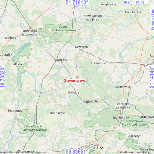
Gowarczów GPS coordinates[2]
51° 16' 42.42" North, 20° 26' 18.06" East
| Map corner | latitude | longitude |
|---|---|---|
| Upper-left | 51.71618°, | 19.73523° |
| Center: | 51.27845°, | 20.43835° |
| Lower-right: | 50.83651°, | 21.14148° |
| Map W x H: | 97.8×97.8 km | = 60.8×60.8mi |
| max Lat: | 54.83135° ⇑47.3% North |
| Gowarczów: | 51.27845° |
| min Lat: | ⇓52.7% South 49.21328° |
| min Long | Gowarczów | max Long |
| 14.20249° | 20.43835° | 24.03723° |
| W 64.2%⇐ | ⇒35.8% E |
Elevation
Elevation of Gowarczów is 235 m = 771 ft, and this is 43.6 m = 143 ft above average elevation for this country.
| Max E: |
974 m = 3196 ft | 28.1% |
| Gowarczów | 235 m 771 ft | |
| Avg. | 191.4 m = 628 ft | |
Min E: |
-3 m = -10 ft | 71.9% |
See also: Poland elevation on elevation.city.
Geographical zone
Gowarczów is located in North temperate zone (between Tropic of Cancer and the Arctic Circle). Distance of this North polar circle is 1699.5 km =1056 mi to North.| Distance of | km | miles | from Gowarczów |
|---|---|---|---|
| North Pole | 4305.4 | 2675.3 | to North |
| Arctic Circle | 1699.5 | 1056 | to North |
| Tropic Cancer | 3095.7 | 1923.6 | to South |
| Equator | 5701.6 | 3542.8 | to South |


Nearby cities:
15 places around Gowarczów: (largest is in red/bold)
• Białaczów
10.1 km =6.3 mi,  282°
282°
• Borkowice
17.7 km =11 mi,  74°
74°
• Bukowiec Opoczyński
19.5 km =12.1 mi,  322°
322°
• Drzewica
19.4 km =12.1 mi,  7°
7°
• Gielniów
13.9 km =8.6 mi, 12°
• Końskie
9.9 km =6.2 mi,  193°
193°
• Mroczków Gościnny
11.8 km =7.3 mi,  343°
343°
• Opoczno
15.5 km =9.6 mi,  314°
314°
• Przysucha
16 km =9.9 mi,  56°
56°
• Rogów
8.3 km =5.2 mi,  181°
181°
• Rusinów
20.4 km =12.7 mi,  30°
30°
• Stąporków
18.2 km =11.3 mi,  149°
149°
• Wielka Wieś
14.6 km =9.1 mi,  133°
133°
• Wola Załężna
15.2 km =9.4 mi,  326°
326°
• Żarnów
18.7 km =11.6 mi,  258°
258°
Sources, notices
• [Note1] Compared only with cities in Poland existing in our database
• [Src1] Map data: © OpenStreetMap contributors (CC-BY-SA)
• [Src2] Other city data from geonames.org with taken over terms of usage.
• [Src3] Geographical zone / Annual Mean Temperature by Robert A. Rohde @ Wikipedia
